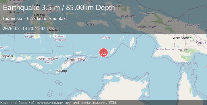
Earthquake Tanimbar Islands Region, Indonesia
Sat, 14 Feb 2026 20:41:07 GMT
Time4 days ago
Location
-7.7667, 130.1123
Depth
84.6 KM
Event Summary
A 3.5 magnitude earthquake struck on Tanimbar Islands Region, Indonesia, at Sat, 14 Feb 2026 20:41:07 GMT. Depth: 84.59967km. Reviewed by BMKG seismologists, this minor quake occurred at a magnitude type of M.
Magnitude
3.5
M
Source
BMKG
Intensity
-
Agency Reports
1 Sources| Source | Magnitude | Depth | Time |
|---|---|---|---|
| BMKGPrimary | 3.5 | 85 km | 4 days ago |
Earthquake Details
ManualEvent IDbmg2026ddzc
Tsunami PotentialNo
Magnitude TypeM
Nearest Places
- Desa Wiratan3.6 km
- Desa Nurnyaman4.0 km
- Pulau Daweloor4.6 km
- Nurnyaman4.6 km
- Kecamatan Dawelor Dawera4.7 km
Comments
Join the discussion about this event.
Latest Earthquakes
2.9Mag
Southern Molucca Sea
Time20 hours ago
Depth170.58 km
SourceBMKG
3.2Mag
northern Colombia
Time20 hours ago
Depth140.50 km
SourceVYT (Automatic)
4.4Mag
Tarapaca, Chile
Time20 hours ago
Depth47.00 km
SourceVYT (Automatic)
1.3Mag
19 km NNW of Borrego Springs, CA
Time20 hours ago
Depth9.65 km
SourceUSGS (Automatic)
2.0Mag
Sweden
Time20 hours ago
Depth10.00 km
SourceVYT (Automatic)
Nearby Earthquakes
5.4Mag
KEP. TANIMBAR REGION, INDONESIA
Time9 years ago
Depth10.00 km
SourceEMSC (Automatic)
3.5Mag
Tanimbar Islands Region, Indonesia
Time1 week ago
Depth105.26 km
SourceBMKG (Automatic)
5.1Mag
KEP. TANIMBAR REGION, INDONESIA
Time3 years ago
Depth60.00 km
SourceEMSC (Automatic)
5.9Mag
Tanimbar Islands Region, Indonesia
Time1 week ago
Depth100.00 km
SourceBMKG (Automatic)
3.1Mag
Kepulauan Tanimbar, Indonesia
Time1 week ago
Depth141.97 km
SourceVYT (Automatic)