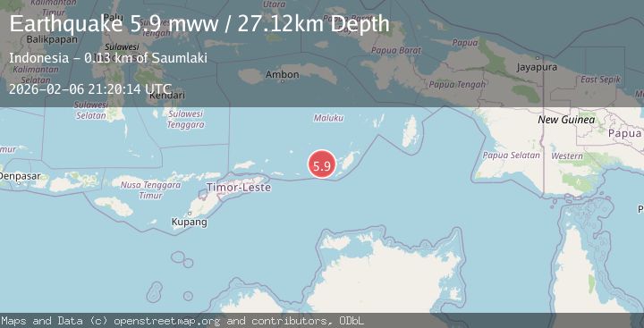
Earthquake Tanimbar Islands Region, Indonesia
Fri, 06 Feb 2026 21:20:16 GMT
Time1 hour ago
Location
-7.8159, 130.2475
Depth
100.0 KM
Event Summary
A 5.9 magnitude earthquake struck on Tanimbar Islands Region, Indonesia, at Fri, 06 Feb 2026 21:20:16 GMT. Depth: 100.00119km. Reviewed by BMKG seismologists, this moderate quake occurred at a magnitude type of M.
Magnitude
5.9
M
Source
BMKG
Intensity
-
Agency Reports
5 Sources| Source | Magnitude | Depth | Time |
|---|---|---|---|
| BMKGPrimary | 5.9 | 100 km | 1 hour ago |
| GFZ | 5.8 | 10 km | 1 hour ago |
| EMSC | 5.8 | 116 km | 1 hour ago |
| NEIC | 5.9 | 27 km | 1 hour ago |
| USGS | 5.9 | 27 km | 1 hour ago |
Earthquake Details
AutomaticEvent IDbmg2026cpki
Tsunami PotentialNo
Magnitude TypeM
Nearest Places
- Desa Nurnyaman19.2 km
- Desa Wiratan19.4 km
- Nurnyaman19.7 km
- Pulau Daweloor20.3 km
- Kecamatan Dawelor Dawera20.5 km
Comments
Join the discussion about this event.
Latest Earthquakes
2.6Mag
Timor Region
Time13 minutes ago
Depth35.89 km
SourceBMKG (Automatic)
2.8Mag
Bali Sea
Time21 minutes ago
Depth15.77 km
SourceBMKG (Automatic)
2.6Mag
Java, Indonesia
Time24 minutes ago
Depth12.69 km
SourceBMKG (Automatic)
1.3Mag
4 km W of Cobb, CA
Time27 minutes ago
Depth2.02 km
SourceUSGS (Automatic)
1.1Mag
2 km ESE of Tres Pinos, CA
Time29 minutes ago
Depth7.90 km
SourceUSGS (Automatic)
Nearby Earthquakes
3.6Mag
Tanimbar Islands Region, Indonesia
Time1 week ago
Depth224.21 km
SourceBMKG (Automatic)
5.0Mag
Tanimbar Islands Region, Indonesia
Time1 week ago
Depth28.16 km
SourceBMKG (Automatic)
3.9Mag
Tanimbar Islands Region, Indonesia
Time1 week ago
Depth10.00 km
SourceBMKG (Automatic)
5.9Mag
Banda Sea
Time2 weeks ago
Depth102.35 km
SourceBMKG (Automatic)
3.5Mag
Banda Sea
Time1 week ago
Depth379.87 km
SourceBMKG (Automatic)