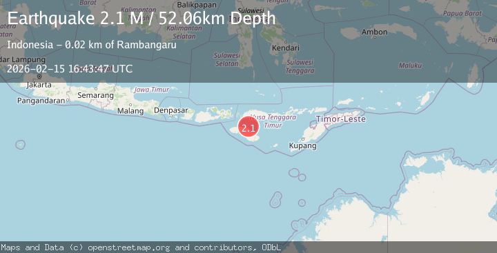
Earthquake Sumba Region, Indonesia
Sun, 15 Feb 2026 16:43:47 GMT
Time3 days ago
Location
-9.3422, 120.1521
Depth
52.1 KM
Event Summary
A 2.1 magnitude earthquake struck on Sumba Region, Indonesia, at Sun, 15 Feb 2026 16:43:47 GMT. Depth: 52.061584km. Reviewed by BMKG seismologists, this minor quake occurred at a magnitude type of M.
Magnitude
2.1
M
Source
BMKG
Intensity
-
Agency Reports
1 Sources| Source | Magnitude | Depth | Time |
|---|---|---|---|
| BMKGPrimary | 2.1 | 52 km | 3 days ago |
Earthquake Details
ManualEvent IDbmg2026dfmu
Tsunami PotentialNo
Magnitude TypeM
Nearest Places
- Tanjung Pambutuwitjukarambua14.3 km
- Tanjung Ngaruruhu14.5 km
- Luku Laramahi14.5 km
- Paluhu14.5 km
- Mananga Paluhu14.8 km
Comments
Join the discussion about this event.
Latest Earthquakes
2.7Mag
Tarapaca, Chile
Time7 hours ago
Depth47.00 km
SourceVYT (Automatic)
1.3Mag
Southeastern Alaska
Time7 hours ago
Depth0.00 km
SourceVYT (Automatic)
1.5Mag
British Columbia, Canada
Time7 hours ago
Depth25.88 km
SourceVYT (Automatic)
2.9Mag
CENTRAL TURKEY
Time7 hours ago
Depth7.00 km
SourceAFAD (Automatic)
2.9Mag
Antofagasta, Chile
Time7 hours ago
Depth109.25 km
SourceVYT (Automatic)
Nearby Earthquakes
3.0Mag
SUMBA REGION, INDONESIA
Time2 years ago
Depth50.00 km
SourceBMKG (Automatic)
2.3Mag
Sumba Region, Indonesia
Time1 week ago
Depth49.56 km
SourceBMKG (Automatic)
2.6Mag
SUMBA REGION, INDONESIA
Time1 month ago
Depth15.00 km
SourceBMKG (Automatic)
2.1Mag
Sumba Region, Indonesia
Time4 days ago
Depth70.45 km
SourceBMKG
5.5Mag
SUMBA REGION, INDONESIA
Time9 years ago
Depth91.00 km
SourceEMSC (Automatic)