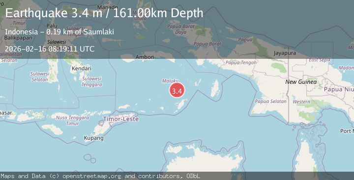
Earthquake Tanimbar Islands Region, Indonesia
Mon, 16 Feb 2026 08:19:11 GMT
Time2 days ago
Location
-6.2811, 131.0834
Depth
161.2 KM
Event Summary
A 3.4 magnitude earthquake struck on Tanimbar Islands Region, Indonesia, at Mon, 16 Feb 2026 08:19:11 GMT. Depth: 161.22554km. Reviewed by BMKG seismologists, this minor quake occurred at a magnitude type of M.
Magnitude
3.4
M
Source
BMKG
Intensity
-
Agency Reports
1 Sources| Source | Magnitude | Depth | Time |
|---|---|---|---|
| BMKGPrimary | 3.4 | 161 km | 2 days ago |
Earthquake Details
ManualEvent IDbmg2026dgrq
Tsunami PotentialNo
Magnitude TypeM
Nearest Places
- Weber Basin32.6 km
- Kepulauan Selatan Daya63.8 km
- Nuhututul69.5 km
- Pulau Kalbur70.1 km
- Melwuarniweyar70.4 km
Comments
Join the discussion about this event.
Latest Earthquakes
1.1Mag
Gaspe Peninsula, Quebec, Canada
Time4 hours ago
Depth0.00 km
SourceVYT (Automatic)
0.7Mag
Southern Alaska
Time4 hours ago
Depth0.00 km
SourceVYT (Automatic)
2.2Mag
Tarapaca, Chile
Time4 hours ago
Depth0.12 km
SourceVYT (Automatic)
3.7Mag
Adriatic Sea
Time4 hours ago
Depth10.00 km
SourceVYT (Automatic)
1.2Mag
4 km W of Lake Henshaw, CA
Time4 hours ago
Depth12.20 km
SourceUSGS (Automatic)
Nearby Earthquakes
5.2Mag
KEP. TANIMBAR REGION, INDONESIA
Time8 years ago
Depth73.00 km
SourceEMSC (Automatic)
5.1Mag
KEP. TANIMBAR REGION, INDONESIA
Time12 years ago
Depth90.00 km
SourceEMSC (Automatic)
3.5Mag
KEP. TANIMBAR REGION, INDONESIA
Time2 weeks ago
Depth14.00 km
SourceBMKG (Automatic)
5.6Mag
BANDA SEA
Time3 months ago
Depth91.50 km
SourceEMSC (Automatic)
3.9Mag
Kepulauan Tanimbar, Indonesia
Time6 days ago
Depth134.52 km
SourceVYT (Automatic)