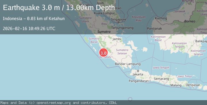
Earthquake Southern Sumatra, Indonesia
Mon, 16 Feb 2026 10:49:26 GMT
Time3 days ago
Location
-3.3813, 101.5855
Depth
12.6 KM
Event Summary
A 3.0 magnitude earthquake struck on Southern Sumatra, Indonesia, at Mon, 16 Feb 2026 10:49:26 GMT. Depth: 12.563418km. Reviewed by BMKG seismologists, this minor quake occurred at a magnitude type of M.
Magnitude
3.0
M
Source
BMKG
Intensity
-
Agency Reports
1 Sources| Source | Magnitude | Depth | Time |
|---|---|---|---|
| BMKGPrimary | 3.0 | 13 km | 3 days ago |
Earthquake Details
ManualEvent IDbmg2026dgwp
Tsunami PotentialNo
Magnitude TypeM
Nearest Places
- Desa Kota Bani15.6 km
- Karangpulau16.3 km
- Sungai Seblat17.1 km
- Seblat17.9 km
- Desa Talang Arah18.2 km
Comments
Join the discussion about this event.
Latest Earthquakes
1.7Mag
STRAIT OF GIBRALTAR
Time8 minutes ago
Depth15.80 km
SourceIGN (Automatic)
3.2Mag
Croatia-Bosnia and Herzegovina border region
Time12 minutes ago
Depth63.84 km
SourceVYT (Automatic)
1.0Mag
Southern Alaska
Time17 minutes ago
Depth13.43 km
SourceVYT (Automatic)
2.7Mag
Southeastern Alaska
Time17 minutes ago
Depth138.92 km
SourceVYT (Automatic)
1.7Mag
8 km ENE of Calumet, Oklahoma
Time18 minutes ago
Depth6.03 km
SourceUSGS (Automatic)
Nearby Earthquakes
2.8Mag
SOUTHERN SUMATRA, INDONESIA
Time1 month ago
Depth34.00 km
SourceBMKG (Automatic)
2.7Mag
SOUTHERN SUMATRA, INDONESIA
Time1 month ago
Depth128.00 km
SourceBMKG (Automatic)
3.0Mag
SOUTHERN SUMATRA, INDONESIA
Time3 years ago
Depth34.00 km
SourceDJA (Automatic)
2.7Mag
SOUTHERN SUMATRA, INDONESIA
Time1 month ago
Depth44.00 km
SourceBMKG (Automatic)
5.0Mag
SOUTHERN SUMATRA, INDONESIA
Time17 years ago
Depth65.00 km
SourceEMSC (Automatic)