Earthquake West Papua, Indonesia
Tue, 17 Feb 2026 17:43:59 GMT
Time18 hours ago
Location
-3.2097, 138.9184
Depth
13.9 KM
Event Summary
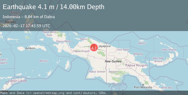
A 4.1 magnitude earthquake struck on West Papua, Indonesia, at Tue, 17 Feb 2026 17:43:59 GMT. Depth: 13.878656km. Reviewed by BMKG seismologists, this light quake occurred at a magnitude type of M.
Magnitude
4.1
M
Source
BMKG
Intensity
-
Agency Reports
1 Sources| Source | Magnitude | Depth | Time |
|---|---|---|---|
| BMKGPrimary | 4.1 | 14 km | 18 hours ago |
Earthquake Details
ManualEvent IDbmg2026djft
Tsunami PotentialNo
Magnitude TypeM
Nearest Places
- Kampung Papedari9.5 km
- Kampung Taria10.7 km
- Kampung Wakumendek16.0 km
- Kampung Tariko16.3 km
- Kampung Muna16.6 km
Comments
Join the discussion about this event.
Latest Earthquakes
3.3Mag
Papua, Indonesia
Time18 hours ago
Depth3.17 km
SourceVYT (Automatic)
2.4Mag
Tarapaca, Chile
Time18 hours ago
Depth86.91 km
SourceVYT (Automatic)
1.1Mag
86 km NNW of Karluk, Alaska
Time18 hours ago
Depth5.00 km
SourceUSGS (Automatic)
2.2Mag
45 km SW of Karluk, Alaska
Time18 hours ago
Depth60.60 km
SourceUSGS (Automatic)
2.6Mag
Antofagasta, Chile
Time18 hours ago
Depth0.00 km
SourceVYT (Automatic)
Nearby Earthquakes
3.0Mag
PAPUA, INDONESIA
Time5 years ago
Depth20.00 km
SourceDJA (Automatic)
5.1Mag
PAPUA, INDONESIA
Time3 years ago
Depth72.00 km
SourceEMSC (Automatic)
5.2Mag
PAPUA, INDONESIA
Time12 years ago
Depth60.00 km
SourceEMSC (Automatic)
3.0Mag
PAPUA, INDONESIA
Time5 years ago
Depth26.00 km
SourceDJA (Automatic)
3.5Mag
PAPUA, INDONESIA
Time1 month ago
Depth19.00 km
SourceBMKG (Automatic)