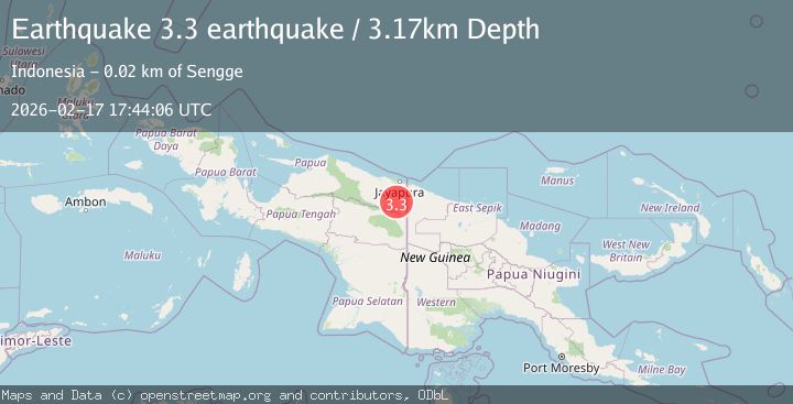
Earthquake Papua, Indonesia
Tue, 17 Feb 2026 17:44:06 GMT
Time17 hours ago
Location
-3.3552, 140.6046
Depth
3.2 KM
Event Summary
A 3.2 magnitude earthquake struck on Papua, Indonesia, at Tue, 17 Feb 2026 17:44:06 GMT. Depth: 3.173828125km. Reviewed by VYT seismologists, this minor quake occurred at a magnitude type of earthquake.
Magnitude
3.2
earthquake
Source
VYT
Intensity
-
Agency Reports
1 Sources| Source | Magnitude | Depth | Time |
|---|---|---|---|
| VYTPrimary | 3.2 | 3 km | 17 hours ago |
Earthquake Details
AutomaticEvent IDvyt_sehotk42k6c5
Tsunami PotentialNo
Magnitude Typeearthquake
Nearest Places
- Distrik Senggi7.8 km
- Kampung Senggi8.8 km
- Kabupaten Keerom9.1 km
- Molof13.9 km
- Kampung Waley14.1 km
Comments
Join the discussion about this event.
Latest Earthquakes
2.4Mag
Tarapaca, Chile
Time17 hours ago
Depth86.91 km
SourceVYT (Automatic)
1.1Mag
86 km NNW of Karluk, Alaska
Time17 hours ago
Depth5.00 km
SourceUSGS (Automatic)
2.2Mag
45 km SW of Karluk, Alaska
Time17 hours ago
Depth60.60 km
SourceUSGS (Automatic)
2.6Mag
Antofagasta, Chile
Time17 hours ago
Depth0.00 km
SourceVYT (Automatic)
2.3Mag
Poland
Time17 hours ago
Depth0.00 km
SourceVYT (Automatic)
Nearby Earthquakes
3.0Mag
PAPUA, INDONESIA
Time2 years ago
Depth60.00 km
SourceDJA (Automatic)
3.1Mag
West Papua, Indonesia
Time3 weeks ago
Depth41.57 km
SourceBMKG (Automatic)
2.8Mag
West Papua, Indonesia
Time3 weeks ago
Depth61.32 km
SourceBMKG (Automatic)
3.0Mag
PAPUA, INDONESIA
Time4 years ago
Depth22.00 km
SourceDJA (Automatic)
3.0Mag
PAPUA, INDONESIA
Time4 months ago
Depth36.00 km
SourceBMKG (Automatic)