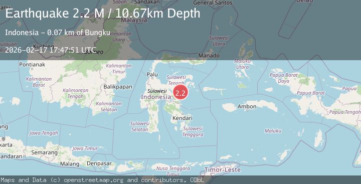
Earthquake Sulawesi, Indonesia
Tue, 17 Feb 2026 17:47:51 GMT
Time15 hours ago
Location
-2.0819, 122.3577
Depth
10.7 KM
Event Summary
A 2.2 magnitude earthquake struck on Sulawesi, Indonesia, at Tue, 17 Feb 2026 17:47:51 GMT. Depth: 10.671618km. Reviewed by BMKG seismologists, this minor quake occurred at a magnitude type of M.
Magnitude
2.2
M
Source
BMKG
Intensity
-
Agency Reports
1 Sources| Source | Magnitude | Depth | Time |
|---|---|---|---|
| BMKGPrimary | 2.2 | 11 km | 15 hours ago |
Earthquake Details
ManualEvent IDbmg2026djfw
Tsunami PotentialNo
Magnitude TypeM
Nearest Places
- Teluk Tolo18.3 km
- Tanjung Buebue55.5 km
- Kuala Mantawa55.7 km
- Mantawa56.2 km
- Desa Mekar Jaya57.5 km
Comments
Join the discussion about this event.
Latest Earthquakes
2.4Mag
Northern Territory, Australia
Time15 hours ago
Depth0.98 km
SourceVYT (Automatic)
2.0Mag
Flores Sea
Time15 hours ago
Depth10.00 km
SourceBMKG
3.3Mag
Papua, Indonesia
Time15 hours ago
Depth3.17 km
SourceVYT (Automatic)
4.1Mag
West Papua, Indonesia
Time15 hours ago
Depth13.88 km
SourceBMKG
2.4Mag
Tarapaca, Chile
Time15 hours ago
Depth86.91 km
SourceVYT (Automatic)
Nearby Earthquakes
3.1Mag
Sulawesi, Indonesia
Time1 day ago
Depth0.98 km
SourceVYT (Automatic)
3.0Mag
SULAWESI, INDONESIA
Time2 years ago
Depth13.00 km
SourceBMKG (Automatic)
4.0Mag
SULAWESI, INDONESIA
Time6 years ago
Depth10.00 km
SourceDJA (Automatic)
3.0Mag
SULAWESI, INDONESIA
Time4 years ago
Depth14.00 km
SourceDJA (Automatic)
3.0Mag
SULAWESI, INDONESIA
Time3 years ago
Depth10.00 km
SourceDJA (Automatic)