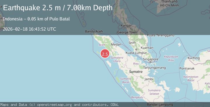
Earthquake Northern Sumatra, Indonesia
Wed, 18 Feb 2026 16:43:49 GMT
Time3 hours ago
Location
2.4904, 96.8064
Depth
9.9 KM
Event Summary
A 2.4 magnitude earthquake struck on Northern Sumatra, Indonesia, at Wed, 18 Feb 2026 16:43:49 GMT. Depth: 9.930204km. Reviewed by BMKG seismologists, this minor quake occurred at a magnitude type of M.
Magnitude
2.4
M
Source
BMKG
Intensity
-
Agency Reports
1 Sources| Source | Magnitude | Depth | Time |
|---|---|---|---|
| BMKGPrimary | 2.4 | 10 km | 3 hours ago |
Earthquake Details
ManualEvent IDbmg2026dkzg
Tsunami PotentialNo
Magnitude TypeM
Nearest Places
- Pulau Batu Selayar34.7 km
- Pulau Batu Belahir35.3 km
- Karang Suffolk35.7 km
- Ujung Silingar36.8 km
- Ujung Labuhanbaja36.9 km
Comments
Join the discussion about this event.
Latest Earthquakes
2.1Mag
Sulawesi, Indonesia
Time3 hours ago
Depth5.00 km
SourceBMKG
2.7Mag
Southern Sumatra, Indonesia
Time3 hours ago
Depth39.33 km
SourceBMKG
4.0Mag
SIBUYAN SEA, PHILIPPINES
Time3 hours ago
Depth10.00 km
SourcePIVS (Automatic)
1.8Mag
Southern Alaska
Time3 hours ago
Depth51.51 km
SourceVYT (Automatic)
1.9Mag
11 km E of Pāhala, Hawaii
Time3 hours ago
Depth30.61 km
SourceUSGS (Automatic)
Nearby Earthquakes
5.1Mag
SIMEULUE, INDONESIA
Time20 years ago
Depth60.00 km
SourceEMSC (Automatic)
4.0Mag
SIMEULUE, INDONESIA
Time7 years ago
Depth50.00 km
SourceDJA (Automatic)
3.0Mag
SIMEULUE, INDONESIA
Time2 years ago
Depth10.00 km
SourceDJA (Automatic)
5.0Mag
SIMEULUE, INDONESIA
Time20 years ago
Depth33.00 km
SourceEMSC (Automatic)
2.7Mag
Northern Sumatra, Indonesia
Time1 week ago
Depth12.09 km
SourceBMKG (Automatic)