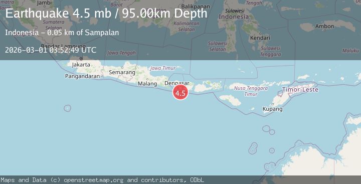
Earthquake South of Bali, Indonesia
Sun, 01 Mar 2026 03:52:51 GMT
Time2 hours ago
Location
-9.2874, 115.5169
Depth
54.9 KM
Event Summary
A 4.8 magnitude earthquake struck on South of Bali, Indonesia, at Sun, 01 Mar 2026 03:52:51 GMT. Depth: 54.920422km. Reviewed by BMKG seismologists, this light quake occurred at a magnitude type of M.
Magnitude
4.8
M
Source
BMKG
Intensity
-
Agency Reports
1 Sources| Source | Magnitude | Depth | Time |
|---|---|---|---|
| BMKGPrimary | 4.8 | 55 km | 2 hours ago |
Earthquake Details
ManualEvent IDbmg2026eecj
Tsunami PotentialNo
Magnitude TypeM
Nearest Places
- 52.6 km
- 53.0 km
- 53.0 km
- 53.1 km
- 53.4 km
Comments
Join the discussion about this event.
Latest Earthquakes
9.8Mag
south of Bali, Indonesia
Time2 hours ago
Depth66.16 km
SourceVYT (Automatic)
1.2Mag
Central Alaska
Time2 hours ago
Depth0.00 km
SourceVYT
3.3Mag
West Papua Region, Indonesia
Time2 hours ago
Depth10.31 km
SourceBMKG
2.8Mag
Flores region, Indonesia
Time2 hours ago
Depth36.50 km
SourceVYT (Automatic)
3.1Mag
Sulawesi, Indonesia
Time2 hours ago
Depth15.26 km
SourceVYT (Automatic)
Nearby Earthquakes
3.0Mag
SOUTH OF BALI, INDONESIA
Time1 month ago
Depth30.00 km
SourceBMKG (Automatic)
9.8Mag
south of Bali, Indonesia
Time2 hours ago
Depth66.16 km
SourceVYT (Automatic)
2.2Mag
South of Bali, Indonesia
Time2 weeks ago
Depth15.58 km
SourceBMKG
5.9Mag
SOUTH OF BALI, INDONESIA
Time16 years ago
Depth64.00 km
SourceEMSC (Automatic)
4.0Mag
SOUTH OF BALI, INDONESIA
Time3 months ago
Depth44.00 km
SourceBMKG (Automatic)