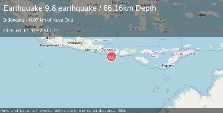
Earthquake south of Bali, Indonesia
Sun, 01 Mar 2026 03:52:51 GMT
Time2 hours ago
Location
-9.3000, 115.5833
Depth
66.2 KM
Event Summary
A 9.8 magnitude earthquake struck on south of Bali, Indonesia, at Sun, 01 Mar 2026 03:52:51 GMT. Depth: 66.162109375km. Reviewed by VYT seismologists, this major quake occurred at a magnitude type of earthquake.
Magnitude
9.8
earthquake
Source
VYT
Intensity
-
Agency Reports
1 Sources| Source | Magnitude | Depth | Time |
|---|---|---|---|
| VYTPrimary | 9.8 | 66 km | 2 hours ago |
Earthquake Details
AutomaticEvent IDvyt_6hz5d98tjln3
Tsunami PotentialNo
Magnitude Typeearthquake
Nearest Places
- 53.5 km
- 53.7 km
- 53.8 km
- 54.0 km
- 54.2 km
Comments
Join the discussion about this event.
Latest Earthquakes
2.8Mag
Flores region, Indonesia
Time2 hours ago
Depth36.50 km
SourceVYT (Automatic)
3.1Mag
Sulawesi, Indonesia
Time2 hours ago
Depth15.26 km
SourceVYT (Automatic)
2.6Mag
10 km SE of Ocotillo Wells, CA
Time2 hours ago
Depth6.19 km
SourceUSGS (Automatic)
2.5Mag
Southern Alaska
Time2 hours ago
Depth40.77 km
SourceVYT (Automatic)
2.7Mag
Southern California
Time2 hours ago
Depth123.90 km
SourceVYT (Automatic)
Nearby Earthquakes
3.0Mag
SOUTH OF BALI, INDONESIA
Time1 month ago
Depth30.00 km
SourceBMKG (Automatic)
4.0Mag
SOUTH OF BALI, INDONESIA
Time3 months ago
Depth44.00 km
SourceBMKG (Automatic)
5.9Mag
SOUTH OF BALI, INDONESIA
Time16 years ago
Depth64.00 km
SourceEMSC (Automatic)
4.2Mag
south of Bali, Indonesia
Time5 days ago
Depth73.85 km
SourceVYT (Automatic)
2.5Mag
SOUTH OF BALI, INDONESIA
Time1 month ago
Depth47.00 km
SourceBMKG (Automatic)