Earthquake SOUTHERN YUKON TERRITORY, CANADA
Mon, 05 Jan 2026 12:25:40 GMT
Time1 month ago
Location
60.5230, -139.9610
Depth
5.0 KM
Event Summary
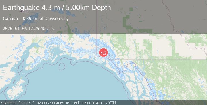
A 4.3 magnitude earthquake struck on SOUTHERN YUKON TERRITORY, CANADA, at Mon, 05 Jan 2026 12:25:40 GMT. Depth: 5km. Reviewed by AK seismologists, this light quake occurred at a magnitude type of m.
Magnitude
4.3
m
Source
AK
Intensity
-
Agency Reports
1 Sources| Source | Magnitude | Depth | Time |
|---|---|---|---|
| AKPrimary | 4.3 | 6 km | 1 month ago |
Earthquake Details
AutomaticEvent IDemsc_AK_20260105_0000360
Tsunami PotentialNo
Magnitude Typem
Nearest Places
- Marker Lake1.9 km
- Mount King George9.5 km
- McArthur Peak16.6 km
- Mount Queen Mary17.4 km
- Mount Vancouver23.3 km
Comments
Join the discussion about this event.
Latest Earthquakes
2.8Mag
Fox Islands, Aleutian Islands, Alaska
Time3 minutes ago
Depth80.44 km
SourceVYT (Automatic)
0.9Mag
110 km S of McCarthy, Alaska
Time5 minutes ago
Depth18.50 km
SourceUSGS (Automatic)
3.0Mag
Central Alaska
Time6 minutes ago
Depth0.12 km
SourceVYT (Automatic)
2.5Mag
Minahassa Peninsula, Sulawesi
Time7 minutes ago
Depth4.95 km
SourceBMKG
2.9Mag
Minahasa, Sulawesi, Indonesia
Time7 minutes ago
Depth10.86 km
SourceVYT (Automatic)
Nearby Earthquakes
3.6Mag
SOUTHERN YUKON TERRITORY, CANADA
Time1 month ago
Depth5.00 km
SourceAK (Automatic)
1.8Mag
110 km N of Yakutat, Alaska
Time3 weeks ago
Depth9.50 km
SourceUSGS
3.0Mag
SOUTHERN YUKON TERRITORY, CANADA
Time2 months ago
Depth5.10 km
SourceNEIC (Automatic)
3.9Mag
SOUTHERN YUKON TERRITORY, CANADA
Time1 month ago
Depth5.00 km
SourceNEIC (Automatic)
2.9Mag
SOUTHERN YUKON TERRITORY, CANADA
Time1 month ago
Depth5.00 km
SourceNEIC (Automatic)