Earthquake WEST OF AUSTRALIA
Mon, 02 Feb 2026 18:33:45 GMT
Time1 hour ago
Location
-31.4000, 111.9700
Depth
10.0 KM
Event Summary
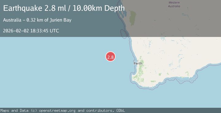
A 2.8 magnitude earthquake struck on WEST OF AUSTRALIA, at Mon, 02 Feb 2026 18:33:45 GMT. Depth: 10km. Reviewed by AUST seismologists, this minor quake occurred at a magnitude type of ml.
Magnitude
2.8
ml
Source
AUST
Intensity
-
Agency Reports
1 Sources| Source | Magnitude | Depth | Time |
|---|---|---|---|
| AUSTPrimary | 2.8 | 10 km | 1 hour ago |
Earthquake Details
AutomaticEvent IDemsc_AUST_20260202_0000308
Tsunami PotentialNo
Magnitude Typeml
Nearest Places
- Perth Canyon244.4 km
- Perth Canyon Marine Park251.9 km
- Geraldton Canyon255.8 km
- Pelsaert Canyon263.0 km
- Wallabi Canyon270.8 km
Comments
Join the discussion about this event.
Latest Earthquakes
2.5Mag
Java, Indonesia
Time1 hour ago
Depth78.16 km
SourceBMKG (Automatic)
1.2Mag
17 km S of Tres Pinos, CA
Time1 hour ago
Depth6.76 km
SourceUSGS (Automatic)
2.3Mag
Northern Sumatra, Indonesia
Time1 hour ago
Depth35.32 km
SourceBMKG (Automatic)
3.4Mag
LA RIOJA, ARGENTINA
Time1 hour ago
Depth117.00 km
SourceNSNA (Automatic)
1.5Mag
37 km NW of Stanton, Texas
Time1 hour ago
Depth4.34 km
SourceUSGS (Automatic)