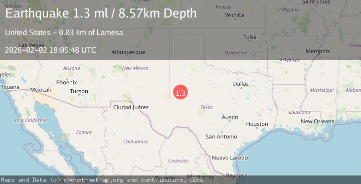
Earthquake 37 km NW of Stanton, Texas
Mon, 02 Feb 2026 18:20:12 GMT
Time3 hours ago
Location
32.3450, -102.0950
Depth
4.3 KM
Event Summary
A 1.3 magnitude earthquake struck on 37 km NW of Stanton, Texas, at Mon, 02 Feb 2026 18:20:12 GMT. Depth: 4.3407km. Reviewed by USGS seismologists, this minor quake occurred at a magnitude type of ml.
Magnitude
1.3
ml
Source
USGS
Intensity
-
Agency Reports
1 Sources| Source | Magnitude | Depth | Time |
|---|---|---|---|
| USGSPrimary | 1.3 | 9 km | 2 hours ago |
Earthquake Details
AutomaticEvent IDusgs_tx2026cidsfz
Tsunami PotentialNo
Magnitude Typeml
Nearest Places
- Flynt Ranch2.6 km
- Hyatt Ranch5.3 km
- West Windmill5.4 km
- Tin Tub Windmill5.4 km
- Midland Pumping Station5.5 km
Comments
Join the discussion about this event.
Latest Earthquakes
2.8Mag
Sulawesi, Indonesia
Time8 minutes ago
Depth10.00 km
SourceBMKG (Automatic)
1.5Mag
5 km SE of San Ramon, CA
Time8 minutes ago
Depth6.55 km
SourceUSGS (Automatic)
3.8Mag
Southern Sumatra, Indonesia
Time10 minutes ago
Depth10.00 km
SourceBMKG (Automatic)
2.4Mag
West Papua Region, Indonesia
Time17 minutes ago
Depth9.36 km
SourceBMKG (Automatic)
4.4Mag
FIJI REGION
Time21 minutes ago
Depth493.40 km
SourceNEIC (Automatic)
Nearby Earthquakes
1.3Mag
36 km NW of Stanton, Texas
Time1 week ago
Depth3.71 km
SourceUSGS (Automatic)
1.3Mag
37 km NW of Stanton, Texas
Time6 days ago
Depth8.80 km
SourceUSGS (Automatic)
1.5Mag
37 km NW of Stanton, Texas
Time6 days ago
Depth4.38 km
SourceUSGS (Automatic)
1.3Mag
38 km NW of Stanton, Texas
Time1 week ago
Depth8.35 km
SourceUSGS (Automatic)
1.2Mag
39 km E of McKinney Acres, Texas
Time3 days ago
Depth2.75 km
SourceUSGS (Automatic)