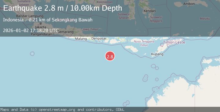
Earthquake SOUTH OF LOMBOK, INDONESIA
Fri, 02 Jan 2026 17:18:20 GMT
Time1 month ago
Location
-10.8200, 116.8500
Depth
10.0 KM
Event Summary
A 2.8 magnitude earthquake struck on SOUTH OF LOMBOK, INDONESIA, at Fri, 02 Jan 2026 17:18:20 GMT. Depth: 10km. Reviewed by BMKG seismologists, this minor quake occurred at a magnitude type of m.
Magnitude
2.8
m
Source
BMKG
Intensity
-
Agency Reports
1 Sources| Source | Magnitude | Depth | Time |
|---|---|---|---|
| BMKGPrimary | 2.8 | 10 km | 1 month ago |
Earthquake Details
AutomaticEvent IDemsc_BMKG_20260102_0000234
Tsunami PotentialNo
Magnitude Typem
Nearest Places
- Lombok Basin143.8 km
- Tanjung Talonan190.5 km
- Tanu Tanjunglilin191.9 km
- Tanjung Moneh192.1 km
- Batu Lawang193.0 km
Comments
Join the discussion about this event.
Latest Earthquakes
1.4Mag
4 km W of Lake Henshaw, CA
Time21 hours ago
Depth12.37 km
SourceUSGS (Automatic)
1.6Mag
41 km NW of Toyah, Texas
Time21 hours ago
Depth3.46 km
SourceUSGS (Automatic)
0.7Mag
6 km WNW of Cobb, CA
Time21 hours ago
Depth-0.59 km
SourceUSGS (Automatic)
1.0Mag
Southern Alaska
Time21 hours ago
Depth0.12 km
SourceVYT (Automatic)
2.1Mag
Sumbawa Region, Indonesia
Time21 hours ago
Depth21.86 km
SourceBMKG
Nearby Earthquakes
2.7Mag
SOUTH OF LOMBOK, INDONESIA
Time1 month ago
Depth23.00 km
SourceBMKG (Automatic)
3.4Mag
SOUTH OF LOMBOK, INDONESIA
Time1 month ago
Depth10.00 km
SourceBMKG (Automatic)
3.0Mag
SOUTH OF LOMBOK, INDONESIA
Time1 month ago
Depth10.00 km
SourceBMKG (Automatic)
5.9Mag
SOUTH OF LOMBOK, INDONESIA
Time19 years ago
Depth2.00 km
SourceEMSC (Automatic)
3.0Mag
SOUTH OF SUMBAWA, INDONESIA
Time3 weeks ago
Depth10.00 km
SourceBMKG (Automatic)