Earthquake Banda Sea
Tue, 17 Feb 2026 02:31:13 GMT
Time2 days ago
Location
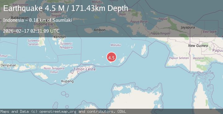
-7.0174, 129.7388
Depth
71.5 KM
Event Summary
A 4.5 magnitude earthquake struck on Banda Sea, at Tue, 17 Feb 2026 02:31:13 GMT. Depth: 71.533203125km. Reviewed by VYT seismologists, this light quake occurred at a magnitude type of earthquake.
Magnitude
4.5
earthquake
Source
VYT
Intensity
-
Agency Reports
2 Sources| Source | Magnitude | Depth | Time |
|---|---|---|---|
| VYTPrimary | 4.3 | 72 km | 2 days ago |
| BMKG | 4.5 | 171 km | 2 days ago |
Earthquake Details
AutomaticEvent IDvyt_20ta3tv4v3eob
Tsunami PotentialNo
Magnitude Typeearthquake
Nearest Places
- Damar Ridge33.4 km
- Tanjung Sifanandrierna38.0 km
- Wotai39.1 km
- Rumadai39.6 km
- Bumai39.9 km
Comments
Join the discussion about this event.
Latest Earthquakes
3.4Mag
Antofagasta, Chile
Time20 hours ago
Depth140.87 km
SourceVYT (Automatic)
2.1Mag
Northern Sumatra, Indonesia
Time20 hours ago
Depth116.35 km
SourceBMKG
2.8Mag
San Juan, Argentina
Time20 hours ago
Depth107.54 km
SourceVYT (Automatic)
2.3Mag
Antofagasta, Chile
Time20 hours ago
Depth0.00 km
SourceVYT (Automatic)
1.2Mag
Southern Alaska
Time20 hours ago
Depth75.93 km
SourceVYT (Automatic)
Nearby Earthquakes
3.7Mag
KEPULAUAN BABAR, INDONESIA
Time1 month ago
Depth174.00 km
SourceBMKG (Automatic)
5.6Mag
KEPULAUAN BABAR, INDONESIA
Time2 years ago
Depth120.00 km
SourceEMSC (Automatic)
4.0Mag
KEPULAUAN BABAR, INDONESIA
Time1 month ago
Depth172.00 km
SourceBMKG (Automatic)
4.6Mag
BANDA SEA
Time1 month ago
Depth138.00 km
SourceEMSC (Automatic)
3.8Mag
KEPULAUAN BABAR, INDONESIA
Time0 months ago
Depth191.00 km
SourceBMKG (Automatic)