Earthquake KEP. TANIMBAR REGION, INDONESIA
Sun, 11 Jan 2026 09:18:15 GMT
Time1 month ago
Location
-6.1800, 131.2600
Depth
76.0 KM
Event Summary
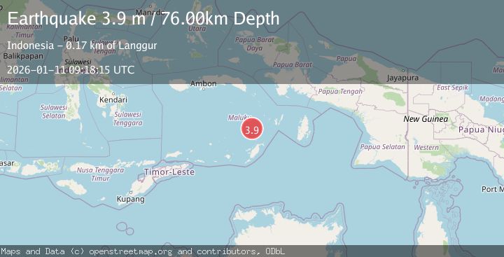
A 3.9 magnitude earthquake struck on KEP. TANIMBAR REGION, INDONESIA, at Sun, 11 Jan 2026 09:18:15 GMT. Depth: 76km. Reviewed by BMKG seismologists, this minor quake occurred at a magnitude type of m.
Magnitude
3.9
m
Source
BMKG
Intensity
-
Agency Reports
1 Sources| Source | Magnitude | Depth | Time |
|---|---|---|---|
| BMKGPrimary | 3.9 | 76 km | 1 month ago |
Earthquake Details
AutomaticEvent IDemsc_BMKG_20260111_0000145
Tsunami PotentialNo
Magnitude Typem
Nearest Places
- Weber Basin35.0 km
- Pulau Kalbur64.5 km
- Nuhututul64.7 km
- Melwuarniweyar66.1 km
- Desa Adodo Molu66.2 km
Comments
Join the discussion about this event.
Latest Earthquakes
1.1Mag
Central Alaska
Time4 minutes ago
Depth74.95 km
SourceVYT (Automatic)
3.8Mag
Atacama, Chile
Time8 minutes ago
Depth113.40 km
SourceVYT (Automatic)
1.4Mag
Southeastern Alaska
Time10 minutes ago
Depth0.00 km
SourceVYT (Automatic)
3.0Mag
northern Sumatra, Indonesia
Time10 minutes ago
Depth10.50 km
SourceVYT (Automatic)
1.1Mag
WESTERN TURKEY
Time11 minutes ago
Depth7.00 km
SourceAFAD (Automatic)
Nearby Earthquakes
3.8Mag
Tanimbar Islands Region, Indonesia
Time2 weeks ago
Depth84.48 km
SourceBMKG (Automatic)
5.4Mag
KEP. TANIMBAR REGION, INDONESIA
Time10 years ago
Depth75.00 km
SourceEMSC (Automatic)
3.3Mag
Tanimbar Islands Region, Indonesia
Time2 weeks ago
Depth209.05 km
SourceBMKG (Automatic)
6.7Mag
KEP. TANIMBAR REGION, INDONESIA
Time7 months ago
Depth65.90 km
SourceEMSC (Automatic)
5.2Mag
KEP. TANIMBAR REGION, INDONESIA
Time11 years ago
Depth51.00 km
SourceEMSC (Automatic)