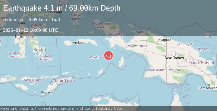
Earthquake KEPULAUAN KAI, INDONESIA
Mon, 12 Jan 2026 10:09:00 GMT
Time1 month ago
Location
-5.2600, 132.5800
Depth
69.0 KM
Event Summary
A 4.1 magnitude earthquake struck on KEPULAUAN KAI, INDONESIA, at Mon, 12 Jan 2026 10:09:00 GMT. Depth: 69km. Reviewed by BMKG seismologists, this light quake occurred at a magnitude type of m.
Magnitude
4.1
m
Source
BMKG
Intensity
-
Agency Reports
1 Sources| Source | Magnitude | Depth | Time |
|---|---|---|---|
| BMKGPrimary | 4.1 | 69 km | 1 month ago |
Earthquake Details
AutomaticEvent IDemsc_BMKG_20260112_0000150
Tsunami PotentialNo
Magnitude Typem
Nearest Places
- Karang Ender14.2 km
- Karang Datu22.6 km
- Karang Batavier24.2 km
- Pulau Roa25.0 km
- Pulau Maas25.5 km
Comments
Join the discussion about this event.
Latest Earthquakes
1.4Mag
Czech Republic
Time59 seconds ago
Depth0.00 km
SourceVYT (Automatic)
2.1Mag
Tarapaca, Chile
Time7 minutes ago
Depth8.18 km
SourceVYT (Automatic)
1.4Mag
12 km ESE of Olancha, CA
Time7 minutes ago
Depth7.15 km
SourceUSGS (Automatic)
2.8Mag
northwestern Russia
Time9 minutes ago
Depth10.00 km
SourceVYT (Automatic)
3.3Mag
Near North Coast of West Papua
Time9 minutes ago
Depth10.00 km
SourceBMKG
Nearby Earthquakes
4.0Mag
NEAR S COAST OF PAPUA, INDONESIA
Time0 years ago
Depth44.00 km
SourceBMKG (Automatic)
5.3Mag
NEAR S COAST OF PAPUA, INDONESIA
Time8 years ago
Depth44.00 km
SourceEMSC (Automatic)
5.4Mag
KEPULAUAN KAI, INDONESIA
Time20 years ago
Depth10.00 km
SourceEMSC (Automatic)
5.0Mag
NEAR S COAST OF PAPUA, INDONESIA
Time1 year ago
Depth11.40 km
SourceEMSC (Automatic)
4.4Mag
BANDA SEA
Time1 month ago
Depth95.00 km
SourceBMKG (Automatic)