Earthquake KEP. MENTAWAI REGION, INDONESIA
Wed, 21 Jan 2026 03:02:47 GMT
Time6 days ago
Location
-1.2600, 99.5900
Depth
48.0 KM
Event Summary
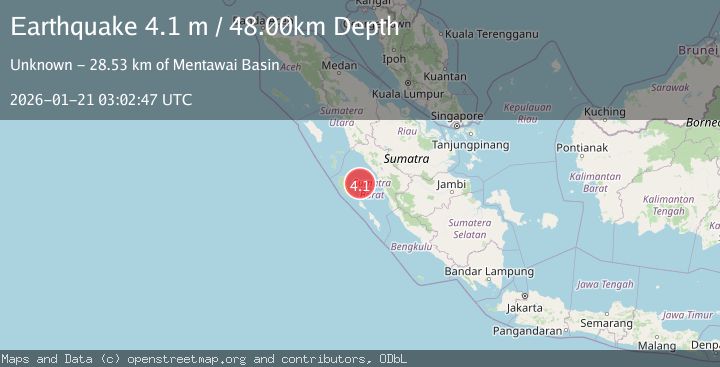
A 4.1 magnitude earthquake struck on KEP. MENTAWAI REGION, INDONESIA, at Wed, 21 Jan 2026 03:02:47 GMT. Depth: 48km. Reviewed by BMKG seismologists, this light quake occurred at a magnitude type of m.
Magnitude
4.1
m
Source
BMKG
Intensity
-
Agency Reports
1 Sources| Source | Magnitude | Depth | Time |
|---|---|---|---|
| BMKGPrimary | 4.1 | 48 km | 6 days ago |
Earthquake Details
AutomaticEvent IDemsc_BMKG_20260121_0000051
Tsunami PotentialNo
Magnitude Typem
Nearest Places
- Mentawai Basin28.5 km
- Pulau Kasik50.9 km
- Tanjung Bubulu51.1 km
- Pulau Ridai51.4 km
- Pulau Sabalat51.5 km
Comments
Join the discussion about this event.
Latest Earthquakes
2.3Mag
Flores Sea
Time16 hours ago
Depth21.75 km
SourceBMKG (Automatic)
2.2Mag
NEVADA
Time16 hours ago
Depth8.30 km
SourceNN (Automatic)
1.8Mag
13 km SSE of Volcano, Hawaii
Time16 hours ago
Depth3.46 km
SourceUSGS (Automatic)
1.4Mag
10 km N of Hollister, CA
Time16 hours ago
Depth10.13 km
SourceUSGS (Automatic)
1.2Mag
13 km WSW of Stanton, Texas
Time16 hours ago
Depth3.46 km
SourceUSGS (Automatic)
Nearby Earthquakes
4.2Mag
Southern Sumatra, Indonesia
Time5 days ago
Depth56.32 km
SourceBMKG (Automatic)
3.0Mag
Southern Sumatra, Indonesia
Time1 day ago
Depth71.81 km
SourceBMKG (Automatic)
2.7Mag
Southern Sumatra, Indonesia
Time1 day ago
Depth22.17 km
SourceBMKG (Automatic)
3.5Mag
Southern Sumatra, Indonesia
Time1 day ago
Depth46.40 km
SourceBMKG (Automatic)
2.5Mag
NORTHERN SUMATRA, INDONESIA
Time3 days ago
Depth8.00 km
SourceBMKG (Automatic)