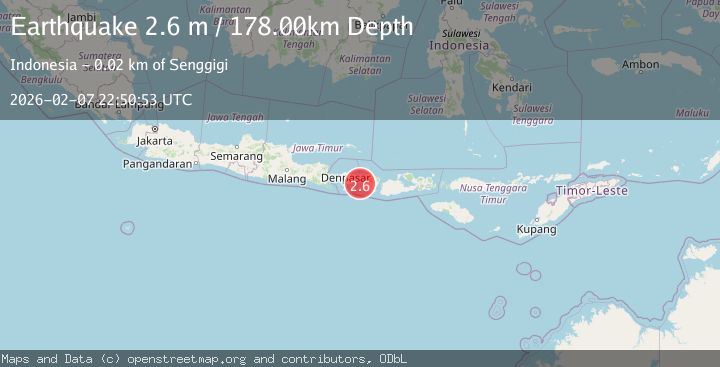
Earthquake BALI REGION, INDONESIA
Sat, 07 Feb 2026 22:50:53 GMT
Time1 hour ago
Location
-8.5700, 115.8600
Depth
178.0 KM
Event Summary
A 2.6 magnitude earthquake struck on BALI REGION, INDONESIA, at Sat, 07 Feb 2026 22:50:53 GMT. Depth: 178km. Reviewed by BMKG seismologists, this minor quake occurred at a magnitude type of m.
Magnitude
2.6
m
Source
BMKG
Intensity
-
Agency Reports
1 Sources| Source | Magnitude | Depth | Time |
|---|---|---|---|
| BMKGPrimary | 2.6 | 178 km | 1 hour ago |
Earthquake Details
AutomaticEvent IDemsc_BMKG_20260207_0000316
Tsunami PotentialNo
Magnitude Typem
Nearest Places
- Selat Lombok7.9 km
- Tanjung Pandanan16.4 km
- Tanjung Bebera17.0 km
- Gili Taketanyaran17.5 km
- Gili Rengit17.6 km
Comments
Join the discussion about this event.
Latest Earthquakes
2.1Mag
70 km WNW of Akhiok, Alaska
Time2 minutes ago
Depth33.90 km
SourceUSGS (Automatic)
2.1Mag
Sulawesi, Indonesia
Time6 minutes ago
Depth6.10 km
SourceBMKG (Automatic)
1.8Mag
24 km SW of Independence, CA
Time8 minutes ago
Depth9.10 km
SourceUSGS (Automatic)
2.1Mag
WESTERN TEXAS
Time11 minutes ago
Depth2.80 km
SourceTX (Automatic)
1.0Mag
7 km E of Fox, Alaska
Time12 minutes ago
Depth4.00 km
SourceUSGS (Automatic)
Nearby Earthquakes
3.5Mag
Bali Region, Indonesia
Time6 days ago
Depth8.96 km
SourceBMKG (Automatic)
2.2Mag
Bali Region, Indonesia
Time2 weeks ago
Depth84.98 km
SourceBMKG (Automatic)
2.1Mag
Sumbawa Region, Indonesia
Time1 week ago
Depth17.97 km
SourceBMKG (Automatic)
2.2Mag
Bali Region, Indonesia
Time6 days ago
Depth20.84 km
SourceBMKG (Automatic)
2.6Mag
Sumbawa Region, Indonesia
Time2 weeks ago
Depth92.11 km
SourceBMKG (Automatic)