Earthquake KEP. TANIMBAR REGION, INDONESIA
Mon, 16 Feb 2026 20:19:39 GMT
Time2 days ago
Location
-6.0200, 132.8300
Depth
61.0 KM
Event Summary
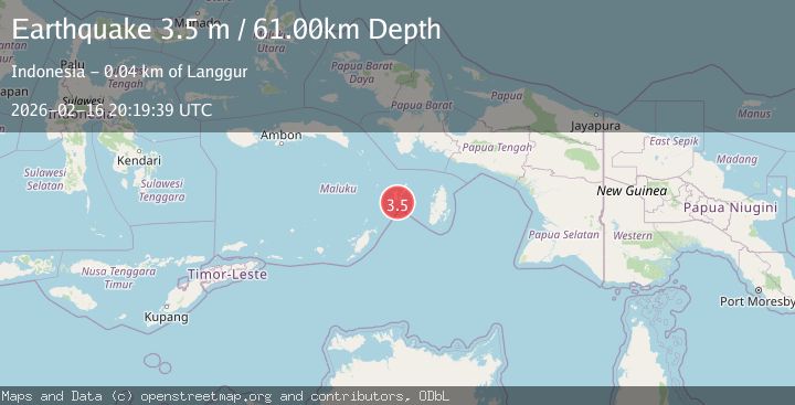
A 3.5 magnitude earthquake struck on KEP. TANIMBAR REGION, INDONESIA, at Mon, 16 Feb 2026 20:19:39 GMT. Depth: 61km. Reviewed by BMKG seismologists, this minor quake occurred at a magnitude type of m.
Magnitude
3.5
m
Source
BMKG
Intensity
-
Agency Reports
1 Sources| Source | Magnitude | Depth | Time |
|---|---|---|---|
| BMKGPrimary | 3.5 | 61 km | 2 days ago |
Earthquake Details
AutomaticEvent IDemsc_BMKG_20260216_0000299
Tsunami PotentialNo
Magnitude Typem
Nearest Places
- Desa Weduar Fer3.0 km
- Tanjung Weduar3.3 km
- Weduarfer4.0 km
- Desa Uat4.0 km
- Desa Ngan5.2 km
Comments
Join the discussion about this event.
Latest Earthquakes
2.3Mag
FRANCE
Time16 hours ago
Depth5.00 km
SourceReNaSS (Automatic)
2.3Mag
FRANCE
Time16 hours ago
Depth9.20 km
SourceReNaSS (Automatic)
1.9Mag
Southern California
Time17 hours ago
Depth0.00 km
SourceVYT (Automatic)
1.1Mag
Southeastern Alaska
Time17 hours ago
Depth31.25 km
SourceVYT (Automatic)
3.3Mag
OFFSHORE CHIAPAS, MEXICO
Time17 hours ago
Depth30.00 km
SourceINET (Automatic)
Nearby Earthquakes
3.8Mag
KEPULAUAN ARU REGION, INDONESIA
Time1 month ago
Depth74.00 km
SourceBMKG (Automatic)
5.4Mag
KEP. TANIMBAR REGION, INDONESIA
Time7 years ago
Depth30.00 km
SourceEMSC (Automatic)
3.5Mag
Tanimbar Islands Region, Indonesia
Time1 week ago
Depth63.97 km
SourceBMKG (Automatic)
5.6Mag
KEP. TANIMBAR REGION, INDONESIA
Time8 years ago
Depth30.00 km
SourceEMSC (Automatic)
5.0Mag
KEP. TANIMBAR REGION, INDONESIA
Time14 years ago
Depth10.00 km
SourceEMSC (Automatic)