Earthquake KEP. TANIMBAR REGION, INDONESIA
Fri, 03 Aug 2018 05:42:14 GMT
Time7 years ago
Location
-6.2500, 132.6900
Depth
30.0 KM
Event Summary
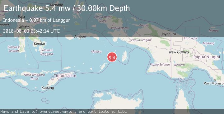
A 5.4 magnitude earthquake struck on KEP. TANIMBAR REGION, INDONESIA, at Fri, 03 Aug 2018 05:42:14 GMT. Depth: 30km. Reviewed by EMSC seismologists, this moderate quake occurred at a magnitude type of mw.
Magnitude
5.4
mw
Source
EMSC
Intensity
-
Agency Reports
1 Sources| Source | Magnitude | Depth | Time |
|---|---|---|---|
| EMSCPrimary | 5.4 | 30 km | 7 years ago |
Earthquake Details
AutomaticEvent IDemsc_EMSC_20180803_0000049
Tsunami PotentialNo
Magnitude Typemw
Nearest Places
- Mitroa27.6 km
- Pulau Noiko32.2 km
- Desa Weduar Fer32.9 km
- Tanjung Weduar33.1 km
- Tanjung Daan33.3 km
Comments
Join the discussion about this event.
Latest Earthquakes
0.8Mag
4 km NW of The Geysers, CA
Time33 minutes ago
Depth2.82 km
SourceUSGS (Automatic)
5.0Mag
Andreanof Islands, Aleutian Islands, Alaska
Time34 minutes ago
Depth132.32 km
SourceVYT (Automatic)
1.6Mag
Southeastern Alaska
Time38 minutes ago
Depth10.13 km
SourceVYT (Automatic)
2.8Mag
Southern California
Time39 minutes ago
Depth5.37 km
SourceVYT (Automatic)
2.7Mag
Java, Indonesia
Time42 minutes ago
Depth14.57 km
SourceBMKG
Nearby Earthquakes
3.5Mag
Tanimbar Islands Region, Indonesia
Time1 week ago
Depth63.97 km
SourceBMKG (Automatic)
5.0Mag
KEP. TANIMBAR REGION, INDONESIA
Time14 years ago
Depth10.00 km
SourceEMSC (Automatic)
5.6Mag
KEP. TANIMBAR REGION, INDONESIA
Time8 years ago
Depth30.00 km
SourceEMSC (Automatic)
3.5Mag
KEP. TANIMBAR REGION, INDONESIA
Time2 days ago
Depth61.00 km
SourceBMKG (Automatic)
3.2Mag
Kepulauan Tanimbar, Indonesia
Time1 week ago
Depth50.29 km
SourceVYT (Automatic)