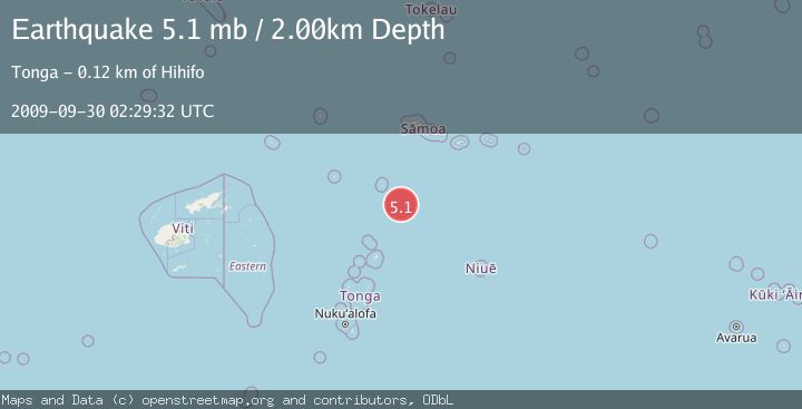
Earthquake SAMOA ISLANDS REGION
Wed, 30 Sep 2009 02:29:32 GMT
Time16 years ago
Location
-16.6500, -172.9900
Depth
2.0 KM
Event Summary
A 5.1 magnitude earthquake struck on SAMOA ISLANDS REGION, at Wed, 30 Sep 2009 02:29:32 GMT. Depth: 2km. Reviewed by EMSC seismologists, this moderate quake occurred at a magnitude type of mb.
Magnitude
5.1
mb
Source
EMSC
Intensity
-
Agency Reports
1 Sources| Source | Magnitude | Depth | Time |
|---|---|---|---|
| EMSCPrimary | 5.1 | 2 km | 16 years ago |
Earthquake Details
AutomaticEvent IDemsc_EMSC_20090930_0000014
Tsunami PotentialNo
Magnitude Typemb
Nearest Places
- 104.8 km
- 109.6 km
- 109.7 km
- 110.3 km
- 111.1 km
Comments
Join the discussion about this event.
Latest Earthquakes
2.2Mag
Southern California
Time1 minute ago
Depth1.59 km
SourceVYT (Automatic)
3.8Mag
North of Halmahera, Indonesia
Time4 minutes ago
Depth37.89 km
SourceBMKG
2.3Mag
Tarapaca, Chile
Time5 minutes ago
Depth128.05 km
SourceVYT (Automatic)
1.2Mag
Southeastern Alaska
Time8 minutes ago
Depth0.00 km
SourceVYT (Automatic)
2.3Mag
134 km E of Chignik, Alaska
Time10 minutes ago
Depth53.90 km
SourceUSGS (Automatic)
Nearby Earthquakes
5.3Mag
TONGA
Time2 years ago
Depth40.00 km
SourceEMSC (Automatic)
5.5Mag
SAMOA ISLANDS REGION
Time17 years ago
Depth29.00 km
SourceEMSC (Automatic)
5.7Mag
TONGA
Time14 years ago
Depth6.00 km
SourceEMSC (Automatic)
5.6Mag
TONGA
Time10 years ago
Depth10.00 km
SourceGFZ (Automatic)
5.1Mag
SAMOA ISLANDS REGION
Time18 years ago
Depth33.00 km
SourceEMSC (Automatic)