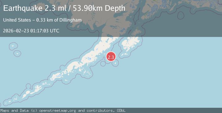
Earthquake 134 km E of Chignik, Alaska
Mon, 23 Feb 2026 01:17:03 GMT
Time1 hour ago
Location
56.3410, -156.2260
Depth
53.9 KM
Event Summary
A 2.3 magnitude earthquake struck on 134 km E of Chignik, Alaska, at Mon, 23 Feb 2026 01:17:03 GMT. Depth: 53.9km. Reviewed by USGS seismologists, this minor quake occurred at a magnitude type of ml.
Magnitude
2.3
ml
Source
USGS
Intensity
-
Agency Reports
1 Sources| Source | Magnitude | Depth | Time |
|---|---|---|---|
| USGSPrimary | 2.3 | 54 km | 1 hour ago |
Earthquake Details
AutomaticEvent IDusgs_aka2026dtkbam
Tsunami PotentialNo
Magnitude Typeml
Nearest Places
- 36.4 km
- 39.0 km
- 39.1 km
- 39.7 km
- 41.3 km
Comments
Join the discussion about this event.
Latest Earthquakes
1.2Mag
Southeastern Alaska
Time1 hour ago
Depth0.00 km
SourceVYT (Automatic)
1.3Mag
Kenai Peninsula, Alaska
Time1 hour ago
Depth31.37 km
SourceVYT (Automatic)
2.1Mag
Tarapaca, Chile
Time1 hour ago
Depth0.00 km
SourceVYT (Automatic)
2.1Mag
Northern Sumatra, Indonesia
Time1 hour ago
Depth8.44 km
SourceBMKG
3.4Mag
NEAR N COAST OF PAPUA, INDONESIA
Time1 hour ago
Depth41.00 km
SourceBMKG (Automatic)
Nearby Earthquakes
3.0Mag
ALASKA PENINSULA
Time7 years ago
Depth66.00 km
SourceNEIR (Automatic)
2.6Mag
ALASKA PENINSULA
Time1 month ago
Depth75.90 km
SourceNEIC (Automatic)
3.0Mag
ALASKA PENINSULA
Time5 years ago
Depth58.00 km
SourceNEIR (Automatic)
3.0Mag
ALASKA PENINSULA
Time8 years ago
Depth59.00 km
SourceNEIR (Automatic)
3.0Mag
ALASKA PENINSULA
Time4 years ago
Depth60.00 km
SourceNEIC (Automatic)