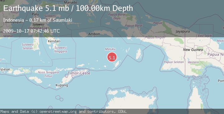
Earthquake BANDA SEA
Sat, 17 Oct 2009 07:42:46 GMT
Time16 years ago
Location
-6.6200, 130.7000
Depth
100.0 KM
Event Summary
A 5.1 magnitude earthquake struck on BANDA SEA, at Sat, 17 Oct 2009 07:42:46 GMT. Depth: 100km. Reviewed by EMSC seismologists, this moderate quake occurred at a magnitude type of mb.
Magnitude
5.1
mb
Source
EMSC
Intensity
-
Agency Reports
1 Sources| Source | Magnitude | Depth | Time |
|---|---|---|---|
| EMSCPrimary | 5.1 | 100 km | 16 years ago |
Earthquake Details
AutomaticEvent IDemsc_EMSC_20091017_0000028
Tsunami PotentialNo
Magnitude Typemb
Nearest Places
- Kepulauan Selatan Daya15.5 km
- Weber Basin76.5 km
- Waru81.6 km
- Pulau Serua83.1 km
- Lesluru84.2 km
Comments
Join the discussion about this event.
Latest Earthquakes
2.8Mag
Sunda Strait, Indonesia
Time13 hours ago
Depth3.61 km
SourceBMKG
3.6Mag
south of Alaska
Time13 hours ago
Depth10.00 km
SourceVYT (Automatic)
1.2Mag
Central Alaska
Time13 hours ago
Depth68.97 km
SourceVYT (Automatic)
1.2Mag
Washington
Time13 hours ago
Depth0.00 km
SourceVYT (Automatic)
0.8Mag
10 km WNW of The Geysers, CA
Time13 hours ago
Depth1.96 km
SourceUSGS (Automatic)
Nearby Earthquakes
5.3Mag
BANDA SEA
Time15 years ago
Depth102.00 km
SourceEMSC (Automatic)
4.0Mag
BANDA SEA
Time2 years ago
Depth79.00 km
SourceBMKG (Automatic)
5.0Mag
BANDA SEA
Time19 years ago
Depth85.00 km
SourceEMSC (Automatic)
5.2Mag
Banda Sea
Time2 weeks ago
Depth110.08 km
SourceBMKG (Automatic)
5.2Mag
BANDA SEA
Time6 years ago
Depth75.00 km
SourceEMSC (Automatic)