Earthquake NEAR S COAST OF PAPUA, INDONESIA
Mon, 21 Jan 2013 18:32:25 GMT
Time13 years ago
Location
-4.4500, 134.8600
Depth
20.0 KM
Event Summary
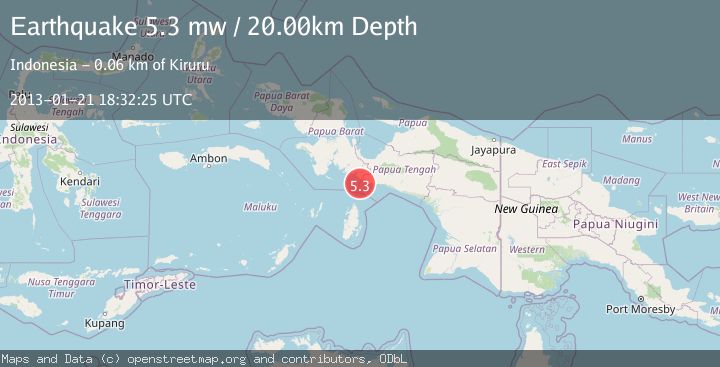
A 5.3 magnitude earthquake struck on NEAR S COAST OF PAPUA, INDONESIA, at Mon, 21 Jan 2013 18:32:25 GMT. Depth: 20km. Reviewed by EMSC seismologists, this moderate quake occurred at a magnitude type of mw.
Magnitude
5.3
mw
Source
EMSC
Intensity
-
Agency Reports
1 Sources| Source | Magnitude | Depth | Time |
|---|---|---|---|
| EMSCPrimary | 5.3 | 20 km | 13 years ago |
Earthquake Details
AutomaticEvent IDemsc_EMSC_20130121_0000050
Tsunami PotentialNo
Magnitude Typemw
Nearest Places
- 20.7 km
- 21.2 km
- 22.1 km
- 22.6 km
- 24.3 km
Comments
Join the discussion about this event.
Latest Earthquakes
3.4Mag
southern Sumatra, Indonesia
Time3 hours ago
Depth57.25 km
SourceVYT (Automatic)
3.4Mag
OFF COAST OF COSTA RICA
Time3 hours ago
Depth5.00 km
SourceINET (Automatic)
4.6Mag
Northern Territory, Australia
Time3 hours ago
Depth143.07 km
SourceVYT (Automatic)
3.5Mag
Papua region, Indonesia
Time3 hours ago
Depth475.22 km
SourceVYT (Automatic)
4.0Mag
North Pacific Ocean
Time3 hours ago
Depth19.29 km
SourceVYT (Automatic)
Nearby Earthquakes
4.0Mag
NEAR S COAST OF PAPUA, INDONESIA
Time6 years ago
Depth45.00 km
SourceDJA (Automatic)
3.5Mag
Papua region, Indonesia
Time3 hours ago
Depth475.22 km
SourceVYT (Automatic)
3.8Mag
West Papua Region, Indonesia
Time1 month ago
Depth11.01 km
SourceBMKG (Automatic)
3.5Mag
West Papua Region, Indonesia
Time1 month ago
Depth76.55 km
SourceBMKG (Automatic)
3.9Mag
West Papua Region, Indonesia
Time1 month ago
Depth61.54 km
SourceBMKG (Automatic)