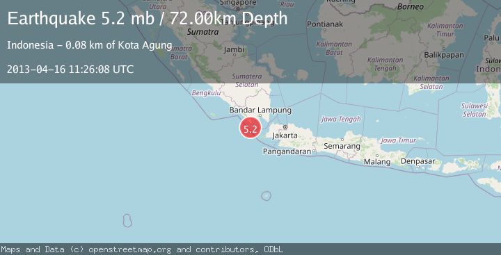
Earthquake SUNDA STRAIT, INDONESIA
Tue, 16 Apr 2013 11:26:08 GMT
Time12 years ago
Location
-6.2000, 104.6700
Depth
72.0 KM
Event Summary
A 5.2 magnitude earthquake struck on SUNDA STRAIT, INDONESIA, at Tue, 16 Apr 2013 11:26:08 GMT. Depth: 72km. Reviewed by EMSC seismologists, this moderate quake occurred at a magnitude type of mb.
Magnitude
5.2
mb
Source
EMSC
Intensity
-
Agency Reports
1 Sources| Source | Magnitude | Depth | Time |
|---|---|---|---|
| EMSCPrimary | 5.2 | 72 km | 12 years ago |
Earthquake Details
AutomaticEvent IDemsc_EMSC_20130416_0000041
Tsunami PotentialNo
Magnitude Typemb
Nearest Places
- Cukuredak Seamount28.4 km
- Wai Belambang29.4 km
- Danau Menjukut30.0 km
- Ujung Saleman30.1 km
- Wai Kejadina30.2 km
Comments
Join the discussion about this event.
Latest Earthquakes
1.7Mag
Southern Alaska
Time14 hours ago
Depth17.09 km
SourceVYT (Automatic)
5.5Mag
Kepulauan Tanimbar, Indonesia
Time14 hours ago
Depth146.36 km
SourceVYT (Automatic)
2.4Mag
Java, Indonesia
Time14 hours ago
Depth27.20 km
SourceBMKG
1.8Mag
49 km NW of Toyah, Texas
Time14 hours ago
Depth3.95 km
SourceUSGS (Automatic)
2.5Mag
offshore Valparaiso, Chile
Time14 hours ago
Depth0.00 km
SourceVYT (Automatic)
Nearby Earthquakes
2.2Mag
Sunda Strait, Indonesia
Time3 days ago
Depth38.26 km
SourceBMKG
5.0Mag
SUNDA STRAIT, INDONESIA
Time5 years ago
Depth68.00 km
SourceEMSC (Automatic)
5.1Mag
SUNDA STRAIT, INDONESIA
Time17 years ago
Depth55.00 km
SourceEMSC (Automatic)
5.4Mag
SUNDA STRAIT, INDONESIA
Time7 months ago
Depth49.70 km
SourceEMSC (Automatic)
3.0Mag
SUNDA STRAIT, INDONESIA
Time4 months ago
Depth10.00 km
SourceBMKG (Automatic)