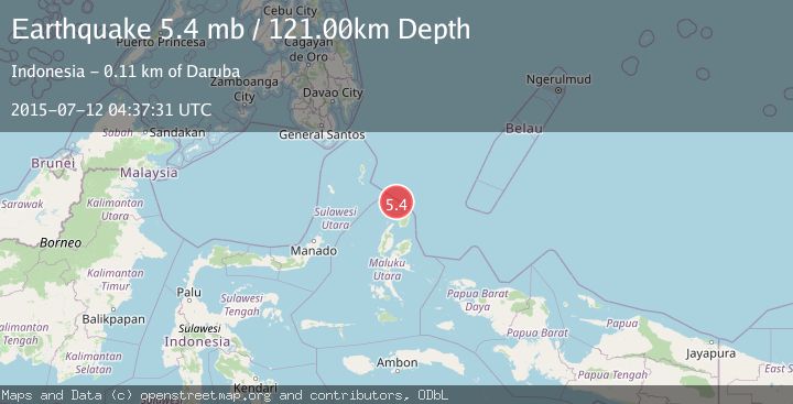
Earthquake NORTH OF HALMAHERA, INDONESIA
Sun, 12 Jul 2015 04:37:31 GMT
Time10 years ago
Location
3.0400, 128.1800
Depth
121.0 KM
Event Summary
A 5.4 magnitude earthquake struck on NORTH OF HALMAHERA, INDONESIA, at Sun, 12 Jul 2015 04:37:31 GMT. Depth: 121km. Reviewed by EMSC seismologists, this moderate quake occurred at a magnitude type of mb.
Magnitude
5.4
mb
Source
EMSC
Intensity
-
Agency Reports
1 Sources| Source | Magnitude | Depth | Time |
|---|---|---|---|
| EMSCPrimary | 5.4 | 121 km | 10 years ago |
Earthquake Details
AutomaticEvent IDemsc_EMSC_20150712_0000011
Tsunami PotentialNo
Magnitude Typemb
Nearest Places
- Morotai Basin20.5 km
- Tanjung Padangi58.8 km
- Tanjung Berri Berri59.1 km
- Padangi60.2 km
- Bere Bere60.3 km
Comments
Join the discussion about this event.
Latest Earthquakes
1.0Mag
29 km W of Garden City, Texas
Time4 minutes ago
Depth3.03 km
SourceUSGS (Automatic)
2.1Mag
6 km NE of Beaverdam, Nevada
Time6 minutes ago
Depth11.45 km
SourceUSGS (Automatic)
3.4Mag
NORTH ISLAND OF NEW ZEALAND
Time13 minutes ago
Depth146.90 km
SourceGNS (Automatic)
2.6Mag
WESTERN TURKEY
Time19 minutes ago
Depth7.30 km
SourceKOERI (Automatic)
3.7Mag
YUNNAN, CHINA
Time20 minutes ago
Depth10.00 km
SourceTSB (Automatic)
Nearby Earthquakes
6.1Mag
NORTH OF HALMAHERA, INDONESIA
Time15 years ago
Depth113.00 km
SourceEMSC (Automatic)
3.7Mag
NORTH OF HALMAHERA, INDONESIA
Time1 month ago
Depth155.00 km
SourceBMKG (Automatic)
5.9Mag
NORTH OF HALMAHERA, INDONESIA
Time1 year ago
Depth110.60 km
SourceEMSC (Automatic)
4.1Mag
North of Halmahera, Indonesia
Time2 weeks ago
Depth5.50 km
SourceBMKG (Automatic)
4.0Mag
NORTH OF HALMAHERA, INDONESIA
Time1 year ago
Depth119.00 km
SourceBMKG (Automatic)