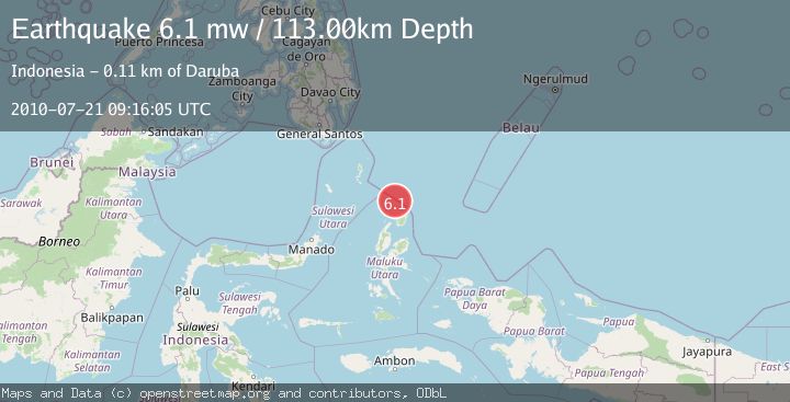
Earthquake NORTH OF HALMAHERA, INDONESIA
Wed, 21 Jul 2010 09:16:05 GMT
Time15 years ago
Location
3.0500, 128.2000
Depth
113.0 KM
Event Summary
A 6.1 magnitude earthquake struck on NORTH OF HALMAHERA, INDONESIA, at Wed, 21 Jul 2010 09:16:05 GMT. Depth: 113km. Reviewed by EMSC seismologists, this strong quake occurred at a magnitude type of mw.
Magnitude
6.1
mw
Source
EMSC
Intensity
-
Agency Reports
1 Sources| Source | Magnitude | Depth | Time |
|---|---|---|---|
| EMSCPrimary | 6.1 | 113 km | 15 years ago |
Earthquake Details
AutomaticEvent IDemsc_EMSC_20100721_0000022
Tsunami PotentialNo
Magnitude Typemw
Nearest Places
- Morotai Basin22.9 km
- Tanjung Padangi58.5 km
- Tanjung Berri Berri59.1 km
- Padangi59.9 km
- Bere Bere60.3 km
Comments
Join the discussion about this event.
Latest Earthquakes
1.0Mag
Southeastern Alaska
Time9 hours ago
Depth0.00 km
SourceVYT (Automatic)
3.5Mag
COOK STRAIT, NEW ZEALAND
Time9 hours ago
Depth75.30 km
SourceGNS (Automatic)
2.4Mag
Seram, Indonesia
Time9 hours ago
Depth18.42 km
SourceBMKG
2.6Mag
West Papua Region, Indonesia
Time9 hours ago
Depth17.35 km
SourceBMKG
2.8Mag
Antofagasta, Chile
Time9 hours ago
Depth0.00 km
SourceVYT (Automatic)
Nearby Earthquakes
5.4Mag
NORTH OF HALMAHERA, INDONESIA
Time10 years ago
Depth121.00 km
SourceEMSC (Automatic)
3.7Mag
NORTH OF HALMAHERA, INDONESIA
Time1 month ago
Depth155.00 km
SourceBMKG (Automatic)
5.9Mag
NORTH OF HALMAHERA, INDONESIA
Time1 year ago
Depth110.60 km
SourceEMSC (Automatic)
4.1Mag
North of Halmahera, Indonesia
Time2 weeks ago
Depth5.50 km
SourceBMKG (Automatic)
4.0Mag
HALMAHERA, INDONESIA
Time1 year ago
Depth14.00 km
SourceBMKG (Automatic)