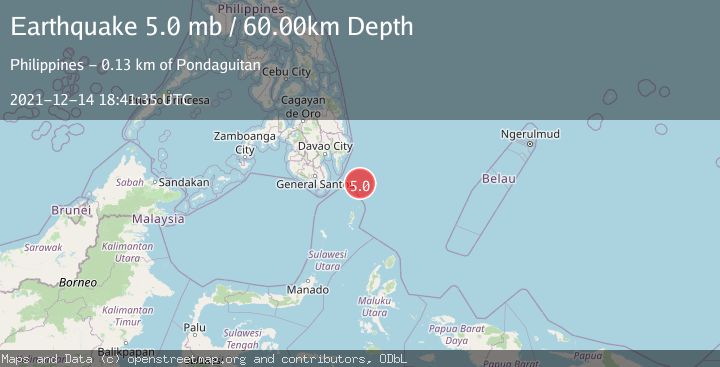
Earthquake PHILIPPINE ISLANDS REGION
Tue, 14 Dec 2021 18:41:35 GMT
Time4 years ago
Location
5.7500, 127.1400
Depth
60.0 KM
Event Summary
A 5.0 magnitude earthquake struck on PHILIPPINE ISLANDS REGION, at Tue, 14 Dec 2021 18:41:35 GMT. Depth: 60km. Reviewed by EMSC seismologists, this moderate quake occurred at a magnitude type of mb.
Magnitude
5.0
mb
Source
EMSC
Intensity
-
Agency Reports
1 Sources| Source | Magnitude | Depth | Time |
|---|---|---|---|
| EMSCPrimary | 5.0 | 60 km | 4 years ago |
Earthquake Details
AutomaticEvent IDemsc_EMSC_20211214_0000354
Tsunami PotentialNo
Magnitude Typemb
Nearest Places
- Tanjung Dapapa64.3 km
- Desa Pulau Miangas65.2 km
- Kecamatan Miangas65.2 km
- Pulau Miangas65.2 km
- Miangas65.8 km
Comments
Join the discussion about this event.
Latest Earthquakes
1.4Mag
Kenai Peninsula, Alaska
Time6 hours ago
Depth1.95 km
SourceVYT (Automatic)
3.1Mag
Northern Sumatra, Indonesia
Time6 hours ago
Depth14.69 km
SourceBMKG
1.9Mag
Channel Islands region, California
Time6 hours ago
Depth2.81 km
SourceVYT (Automatic)
3.3Mag
Southern Alaska
Time6 hours ago
Depth13.06 km
SourceVYT (Automatic)
1.9Mag
Southern Yukon Territory, Canada
Time6 hours ago
Depth0.00 km
SourceVYT (Automatic)
Nearby Earthquakes
5.6Mag
PHILIPPINE ISLANDS REGION
Time8 years ago
Depth69.00 km
SourceEMSC (Automatic)
3.0Mag
PHILIPPINE ISLANDS REGION
Time2 years ago
Depth63.00 km
SourcePIVS (Automatic)
5.6Mag
PHILIPPINE ISLANDS REGION
Time5 years ago
Depth60.00 km
SourceEMSC (Automatic)
5.0Mag
PHILIPPINE ISLANDS REGION
Time16 years ago
Depth30.00 km
SourceEMSC (Automatic)
3.2Mag
PHILIPPINE ISLANDS REGION
Time1 month ago
Depth70.00 km
SourcePIVS (Automatic)