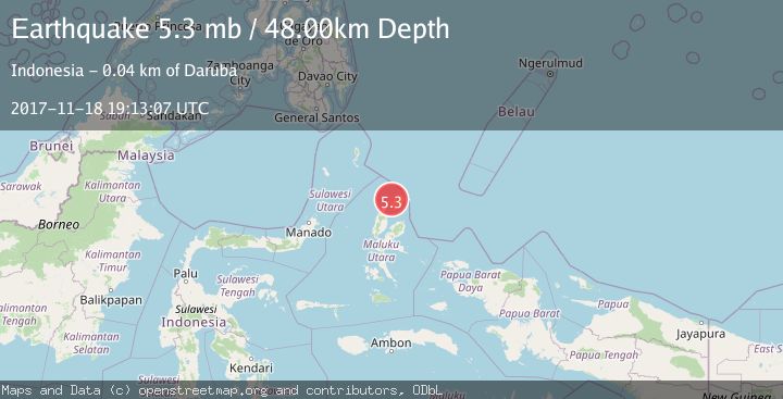
Earthquake HALMAHERA, INDONESIA
Sat, 18 Nov 2017 19:13:07 GMT
Time8 years ago
Location
2.4200, 128.2200
Depth
48.0 KM
Event Summary
A 5.3 magnitude earthquake struck on HALMAHERA, INDONESIA, at Sat, 18 Nov 2017 19:13:07 GMT. Depth: 48km. Reviewed by EMSC seismologists, this moderate quake occurred at a magnitude type of mb.
Magnitude
5.3
mb
Source
EMSC
Intensity
-
Agency Reports
1 Sources| Source | Magnitude | Depth | Time |
|---|---|---|---|
| EMSCPrimary | 5.3 | 15 km | 8 years ago |
Earthquake Details
AutomaticEvent IDemsc_EMSC_20171118_0000072
Tsunami PotentialNo
Magnitude Typemb
Nearest Places
- Pulau Tuanane5.9 km
- Tanjung Papaye6.0 km
- Laumadoro6.4 km
- Aru6.6 km
- Pulau Ganopu Misahe7.0 km
Comments
Join the discussion about this event.
Latest Earthquakes
2.1Mag
Ceram Sea
Time20 hours ago
Depth10.00 km
SourceBMKG
3.1Mag
Ceram Sea
Time20 hours ago
Depth10.00 km
SourceBMKG
3.1Mag
Antofagasta, Chile
Time20 hours ago
Depth122.80 km
SourceVYT (Automatic)
0.7Mag
8 km NW of The Geysers, CA
Time21 hours ago
Depth6.62 km
SourceUSGS (Automatic)
1.7Mag
Southern Alaska
Time21 hours ago
Depth2.81 km
SourceVYT (Automatic)
Nearby Earthquakes
3.9Mag
Halmahera, Indonesia
Time1 day ago
Depth70.80 km
SourceVYT (Automatic)
5.3Mag
HALMAHERA, INDONESIA
Time13 years ago
Depth170.00 km
SourceEMSC (Automatic)
4.0Mag
HALMAHERA, INDONESIA
Time6 years ago
Depth164.00 km
SourceDJA (Automatic)
3.0Mag
HALMAHERA, INDONESIA
Time1 year ago
Depth10.00 km
SourceBMKG (Automatic)
4.0Mag
HALMAHERA, INDONESIA
Time6 years ago
Depth132.00 km
SourceDJA (Automatic)