Earthquake NORTHERN SUMATRA, INDONESIA
Thu, 08 Feb 2018 09:52:48 GMT
Time8 years ago
Location
4.8100, 96.1900
Depth
13.0 KM
Event Summary
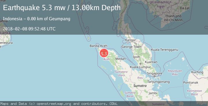
A 5.3 magnitude earthquake struck on NORTHERN SUMATRA, INDONESIA, at Thu, 08 Feb 2018 09:52:48 GMT. Depth: 13km. Reviewed by EMSC seismologists, this moderate quake occurred at a magnitude type of mw.
Magnitude
5.3
mw
Source
EMSC
Intensity
-
Agency Reports
1 Sources| Source | Magnitude | Depth | Time |
|---|---|---|---|
| EMSCPrimary | 5.3 | 13 km | 8 years ago |
Earthquake Details
AutomaticEvent IDemsc_EMSC_20180208_0000039
Tsunami PotentialNo
Magnitude Typemw
Nearest Places
- Gunung Aluekala1.3 km
- Gunung Hudah1.5 km
- Gunung Hudah2.8 km
- Gunung Tengku Dijawa3.4 km
- Alue Pisangbeuh3.5 km
Comments
Join the discussion about this event.
Latest Earthquakes
1.5Mag
Alaska Peninsula
Time10 hours ago
Depth31.37 km
SourceVYT (Automatic)
1.4Mag
Kenai Peninsula, Alaska
Time10 hours ago
Depth35.28 km
SourceVYT (Automatic)
1.1Mag
87 km N of Karluk, Alaska
Time10 hours ago
Depth5.00 km
SourceUSGS (Automatic)
2.3Mag
Southern Sumatra, Indonesia
Time10 hours ago
Depth36.72 km
SourceBMKG
2.6Mag
Java, Indonesia
Time10 hours ago
Depth62.13 km
SourceBMKG
Nearby Earthquakes
3.0Mag
NORTHERN SUMATRA, INDONESIA
Time8 months ago
Depth10.00 km
SourceBMKG (Automatic)
3.0Mag
NORTHERN SUMATRA, INDONESIA
Time4 years ago
Depth13.00 km
SourceDJA (Automatic)
3.2Mag
northern Sumatra, Indonesia
Time2 days ago
Depth0.00 km
SourceVYT (Automatic)
2.1Mag
Northern Sumatra, Indonesia
Time3 weeks ago
Depth8.15 km
SourceBMKG (Automatic)
2.7Mag
NORTHERN SUMATRA, INDONESIA
Time1 month ago
Depth13.00 km
SourceBMKG (Automatic)