Earthquake Bali Region, Indonesia
Mon, 09 Feb 2026 02:02:06 GMT
Time3 hours ago
Location
-8.2540, 114.9454
Depth
22.1 KM
Event Summary
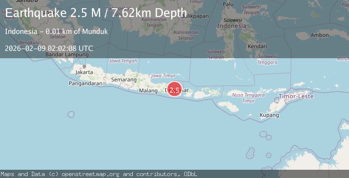
A 2.2 magnitude earthquake struck on Bali Region, Indonesia, at Mon, 09 Feb 2026 02:02:06 GMT. Depth: 22.12178km. Reviewed by BMKG seismologists, this minor quake occurred at a magnitude type of M.
Magnitude
2.2
M
Source
BMKG
Intensity
-
Agency Reports
1 Sources| Source | Magnitude | Depth | Time |
|---|---|---|---|
| BMKGPrimary | 2.2 | 22 km | 3 hours ago |
Earthquake Details
AutomaticEvent IDbmg2026ctkq
Tsunami PotentialNo
Magnitude TypeM
Nearest Places
- Tukadyeh Panas0.5 km
- Kabupaten Buleleng0.7 km
- Munduk Kelod0.7 km
- Kelod0.8 km
- Angsa1.0 km
Comments
Join the discussion about this event.
Latest Earthquakes
2.7Mag
Sumbawa Region, Indonesia
Time3 hours ago
Depth24.10 km
SourceBMKG (Automatic)
3.2Mag
Halmahera, Indonesia
Time3 hours ago
Depth0.00 km
SourceBMKG (Automatic)
3.3Mag
VIRGIN ISLANDS REGION
Time4 hours ago
Depth35.00 km
SourceNEIC (Automatic)
2.5Mag
Northern Sumatra, Indonesia
Time4 hours ago
Depth4.77 km
SourceBMKG (Automatic)
1.6Mag
4 km ENE of Saint Helena, CA
Time4 hours ago
Depth8.01 km
SourceUSGS (Automatic)
Nearby Earthquakes
2.2Mag
Bali Region, Indonesia
Time1 week ago
Depth13.17 km
SourceBMKG (Automatic)
2.5Mag
Bali Region, Indonesia
Time2 weeks ago
Depth90.70 km
SourceBMKG (Automatic)
2.5Mag
Bali Region, Indonesia
Time2 weeks ago
Depth105.42 km
SourceBMKG (Automatic)
2.4Mag
Bali Region, Indonesia
Time1 week ago
Depth110.29 km
SourceBMKG (Automatic)
2.7Mag
Bali Region, Indonesia
Time1 week ago
Depth46.02 km
SourceBMKG (Automatic)