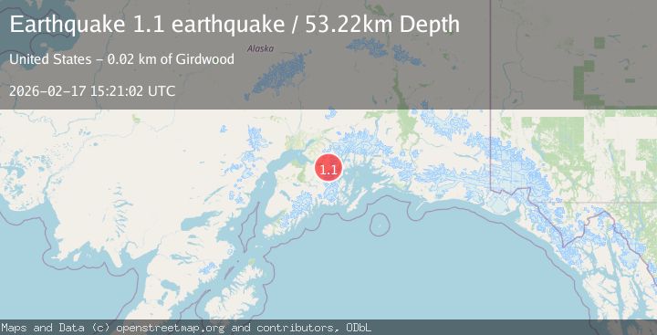
Earthquake Kenai Peninsula, Alaska
Tue, 17 Feb 2026 15:21:02 GMT
Time20 hours ago
Location
60.8335, -148.7846
Depth
53.2 KM
Event Summary
A 1.1 magnitude earthquake struck on Kenai Peninsula, Alaska, at Tue, 17 Feb 2026 15:21:02 GMT. Depth: 53.22265625km. Reviewed by VYT seismologists, this minor quake occurred at a magnitude type of earthquake.
Magnitude
1.1
earthquake
Source
VYT
Intensity
-
Agency Reports
1 Sources| Source | Magnitude | Depth | Time |
|---|---|---|---|
| VYTPrimary | 1.1 | 53 km | 20 hours ago |
Earthquake Details
AutomaticEvent IDvyt_3294rmocee0pb
Tsunami PotentialNo
Magnitude Typeearthquake
Nearest Places
- Boggs Peak1.2 km
- Begich Peak2.5 km
- Begich Peak2.7 km
- Maynard Mountain4.0 km
- Learnard Glacier4.4 km
Comments
Join the discussion about this event.
Latest Earthquakes
1.5Mag
Southern Alaska
Time20 hours ago
Depth67.26 km
SourceVYT (Automatic)
2.4Mag
Northern Sumatra, Indonesia
Time20 hours ago
Depth8.31 km
SourceBMKG
1.2Mag
10 km NW of The Geysers, CA
Time20 hours ago
Depth1.41 km
SourceUSGS (Automatic)
1.0Mag
Southern Alaska
Time20 hours ago
Depth14.53 km
SourceVYT (Automatic)
3.5Mag
Kepulauan Mentawai region, Indonesia
Time20 hours ago
Depth29.42 km
SourceVYT (Automatic)
Nearby Earthquakes
1.5Mag
Kenai Peninsula, Alaska
Time3 days ago
Depth88.38 km
SourceVYT (Automatic)
1.7Mag
Kenai Peninsula, Alaska
Time1 day ago
Depth0.00 km
SourceVYT (Automatic)
3.0Mag
KENAI PENINSULA, ALASKA
Time7 years ago
Depth20.00 km
SourceNEIR (Automatic)
1.5Mag
Kenai Peninsula, Alaska
Time5 days ago
Depth31.01 km
SourceVYT (Automatic)
3.0Mag
KENAI PENINSULA, ALASKA
Time11 years ago
Depth13.00 km
SourceNEIR (Automatic)