Earthquake KEP. TANIMBAR REGION, INDONESIA
Wed, 26 Feb 2020 07:33:11 GMT
Time6 years ago
Location
-7.5500, 131.2000
Depth
40.0 KM
Event Summary
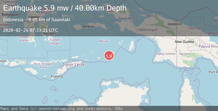
A 5.9 magnitude earthquake struck on KEP. TANIMBAR REGION, INDONESIA, at Wed, 26 Feb 2020 07:33:11 GMT. Depth: 40km. Reviewed by EMSC seismologists, this moderate quake occurred at a magnitude type of mw.
Magnitude
5.9
mw
Source
EMSC
Intensity
-
Agency Reports
1 Sources| Source | Magnitude | Depth | Time |
|---|---|---|---|
| EMSCPrimary | 5.9 | 40 km | 6 years ago |
Earthquake Details
AutomaticEvent IDemsc_EMSC_20200226_0000051
Tsunami PotentialNo
Magnitude Typemw
Nearest Places
- 3.1 km
- 5.0 km
- 5.2 km
- 5.5 km
- 5.9 km
Comments
Join the discussion about this event.
Latest Earthquakes
1.9Mag
Central Alaska
Time3 hours ago
Depth0.00 km
SourceVYT (Automatic)
3.4Mag
Kepulauan Tanimbar, Indonesia
Time3 hours ago
Depth375.24 km
SourceVYT (Automatic)
2.8Mag
Western Australia
Time3 hours ago
Depth0.00 km
SourceVYT (Automatic)
1.3Mag
17 km SE of Julian, CA
Time3 hours ago
Depth6.94 km
SourceUSGS (Automatic)
1.3Mag
Western Australia
Time3 hours ago
Depth13.79 km
SourceVYT (Automatic)
Nearby Earthquakes
4.0Mag
KEP. TANIMBAR REGION, INDONESIA
Time1 year ago
Depth30.00 km
SourceBMKG (Automatic)
5.4Mag
KEP. TANIMBAR REGION, INDONESIA
Time13 years ago
Depth46.00 km
SourceEMSC (Automatic)
5.5Mag
KEP. TANIMBAR REGION, INDONESIA
Time10 years ago
Depth60.00 km
SourceEMSC (Automatic)
4.0Mag
KEP. TANIMBAR REGION, INDONESIA
Time4 years ago
Depth241.00 km
SourceDJA (Automatic)
5.1Mag
KEP. TANIMBAR REGION, INDONESIA
Time7 years ago
Depth45.00 km
SourceEMSC (Automatic)