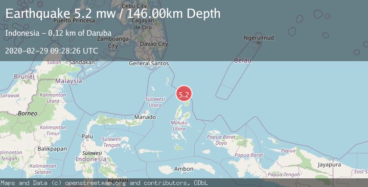
Earthquake NORTH OF HALMAHERA, INDONESIA
Sat, 29 Feb 2020 09:28:26 GMT
Time5 years ago
Location
3.1600, 128.2200
Depth
146.0 KM
Event Summary
A 5.2 magnitude earthquake struck on NORTH OF HALMAHERA, INDONESIA, at Sat, 29 Feb 2020 09:28:26 GMT. Depth: 146km. Reviewed by EMSC seismologists, this moderate quake occurred at a magnitude type of mw.
Magnitude
5.2
mw
Source
EMSC
Intensity
-
Agency Reports
1 Sources| Source | Magnitude | Depth | Time |
|---|---|---|---|
| EMSCPrimary | 5.2 | 146 km | 5 years ago |
Earthquake Details
AutomaticEvent IDemsc_EMSC_20200229_0000060
Tsunami PotentialNo
Magnitude Typemw
Nearest Places
- Morotai Basin30.2 km
- Tanjung Padangi68.4 km
- Tanjung Sopi69.2 km
- Tanjung Berri Berri69.5 km
- Kakaibabao69.5 km
Comments
Join the discussion about this event.
Latest Earthquakes
4.5Mag
North of Halmahera, Indonesia
Time7 minutes ago
Depth10.00 km
SourceBMKG
3.1Mag
Bali Region, Indonesia
Time13 minutes ago
Depth19.14 km
SourceBMKG
2.7Mag
Coquimbo, Chile
Time14 minutes ago
Depth14.16 km
SourceVYT (Automatic)
1.7Mag
Southeastern Alaska
Time17 minutes ago
Depth5.98 km
SourceVYT (Automatic)
2.1Mag
Tarapaca, Chile
Time18 minutes ago
Depth110.35 km
SourceVYT (Automatic)
Nearby Earthquakes
5.2Mag
NORTH OF HALMAHERA, INDONESIA
Time12 years ago
Depth60.00 km
SourceEMSC (Automatic)
5.3Mag
NORTH OF HALMAHERA, INDONESIA
Time10 years ago
Depth133.00 km
SourceEMSC (Automatic)
5.1Mag
NORTH OF HALMAHERA, INDONESIA
Time11 years ago
Depth60.00 km
SourceEMSC (Automatic)
5.8Mag
NORTH OF HALMAHERA, INDONESIA
Time20 years ago
Depth33.00 km
SourceEMSC (Automatic)
6.1Mag
NORTH OF HALMAHERA, INDONESIA
Time15 years ago
Depth113.00 km
SourceEMSC (Automatic)