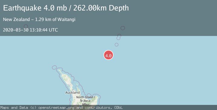
Earthquake SOUTH OF KERMADEC ISLANDS
Mon, 30 Mar 2020 13:10:44 GMT
Time5 years ago
Location
-32.6300, -179.9800
Depth
262.0 KM
Event Summary
A 4.0 magnitude earthquake struck on SOUTH OF KERMADEC ISLANDS, at Mon, 30 Mar 2020 13:10:44 GMT. Depth: 262km. Reviewed by EMSC seismologists, this light quake occurred at a magnitude type of mb.
Magnitude
4.0
mb
Source
EMSC
Intensity
-
Agency Reports
1 Sources| Source | Magnitude | Depth | Time |
|---|---|---|---|
| EMSCPrimary | 4.0 | 262 km | 5 years ago |
Earthquake Details
AutomaticEvent IDemsc_EMSC_20200330_0000222
Tsunami PotentialNo
Magnitude Typemb
Nearest Places
- Haungaroa Seamount32.4 km
- Oliver Knoll39.0 km
- Speight Knoll45.5 km
- Kuiwai Seamount59.7 km
- Star of Bengal Bank85.8 km
Comments
Join the discussion about this event.
Latest Earthquakes
0.4Mag
31 km NW of Toyah, Texas
Time3 minutes ago
Depth4.11 km
SourceUSGS (Automatic)
2.5Mag
Tarapaca, Chile
Time8 minutes ago
Depth0.12 km
SourceVYT (Automatic)
2.3Mag
West Papua Region, Indonesia
Time14 minutes ago
Depth10.00 km
SourceBMKG
2.3Mag
FRANCE
Time16 minutes ago
Depth5.00 km
SourceReNaSS (Automatic)
2.6Mag
Tarapaca, Chile
Time20 minutes ago
Depth106.08 km
SourceVYT (Automatic)
Nearby Earthquakes
3.7Mag
SOUTH OF KERMADEC ISLANDS
Time1 month ago
Depth331.80 km
SourceGNS (Automatic)
4.0Mag
SOUTH OF KERMADEC ISLANDS
Time2 years ago
Depth340.20 km
SourceEMSC (Automatic)
5.2Mag
SOUTH OF KERMADEC ISLANDS
Time16 years ago
Depth47.00 km
SourceEMSC (Automatic)
5.3Mag
SOUTH OF KERMADEC ISLANDS
Time12 years ago
Depth218.00 km
SourceEMSC (Automatic)
4.0Mag
SOUTH OF KERMADEC ISLANDS
Time5 years ago
Depth453.00 km
SourceGNS (Automatic)