Earthquake MYANMAR-INDIA BORDER REGION
Thu, 27 Aug 2020 12:07:15 GMT
Time5 years ago
Location
23.2000, 93.4200
Depth
10.0 KM
Event Summary
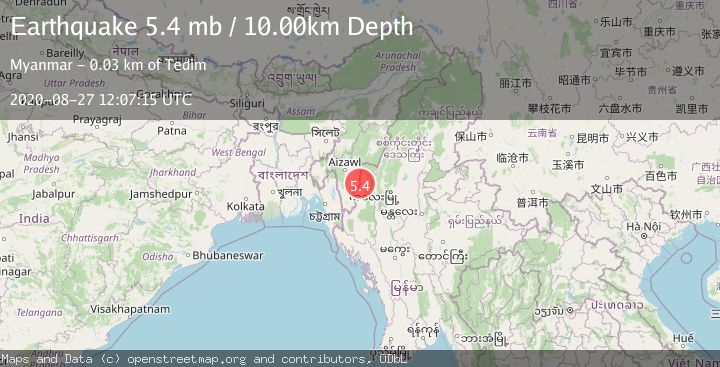
A 5.4 magnitude earthquake struck on MYANMAR-INDIA BORDER REGION, at Thu, 27 Aug 2020 12:07:15 GMT. Depth: 10km. Reviewed by EMSC seismologists, this moderate quake occurred at a magnitude type of mb.
Magnitude
5.4
mb
Source
EMSC
Intensity
-
Agency Reports
1 Sources| Source | Magnitude | Depth | Time |
|---|---|---|---|
| EMSCPrimary | 5.4 | 10 km | 5 years ago |
Earthquake Details
AutomaticEvent IDemsc_EMSC_20200827_0000089
Tsunami PotentialNo
Magnitude Typemb
Nearest Places
Comments
Join the discussion about this event.
Latest Earthquakes
2.7Mag
Bali Sea
Time5 minutes ago
Depth17.45 km
SourceBMKG
2.2Mag
Southern California
Time9 minutes ago
Depth3.91 km
SourceVYT (Automatic)
2.5Mag
18 km W of Delta, B.C., MX
Time10 minutes ago
Depth10.16 km
SourceUSGS (Automatic)
6.1Mag
eastern New Guinea region, Papua New Guinea
Time13 minutes ago
Depth91.67 km
SourceVYT (Automatic)
1.8Mag
Antofagasta, Chile
Time17 minutes ago
Depth0.00 km
SourceVYT (Automatic)
Nearby Earthquakes
5.1Mag
MYANMAR-INDIA BORDER REGION
Time5 years ago
Depth10.00 km
SourceEMSC (Automatic)
5.6Mag
MYANMAR-INDIA BORDER REGION
Time5 years ago
Depth10.00 km
SourceEMSC (Automatic)
3.3Mag
MYANMAR-INDIA BORDER REGION
Time6 days ago
Depth31.10 km
SourceNDI (Automatic)
5.4Mag
MYANMAR-INDIA BORDER REGION
Time4 years ago
Depth57.00 km
SourceEMSC (Automatic)
5.0Mag
MYANMAR-INDIA BORDER REGION
Time5 years ago
Depth60.00 km
SourceEMSC (Automatic)