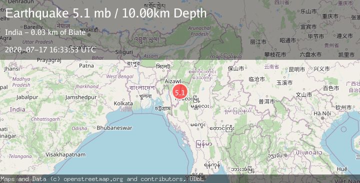
Earthquake MYANMAR-INDIA BORDER REGION
Fri, 17 Jul 2020 16:33:53 GMT
Time5 years ago
Location
23.2100, 93.3800
Depth
10.0 KM
Event Summary
A 5.1 magnitude earthquake struck on MYANMAR-INDIA BORDER REGION, at Fri, 17 Jul 2020 16:33:53 GMT. Depth: 10km. Reviewed by EMSC seismologists, this moderate quake occurred at a magnitude type of mb.
Magnitude
5.1
mb
Source
EMSC
Intensity
-
Agency Reports
1 Sources| Source | Magnitude | Depth | Time |
|---|---|---|---|
| EMSCPrimary | 5.1 | 10 km | 5 years ago |
Earthquake Details
AutomaticEvent IDemsc_EMSC_20200717_0000116
Tsunami PotentialNo
Magnitude Typemb
Nearest Places
- 3.5 km
- 4.6 km
- 5.0 km
- 5.0 km
- 5.6 km
Comments
Join the discussion about this event.
Latest Earthquakes
1.5Mag
17 km S of Hawthorne, Nevada
Time4 minutes ago
Depth4.19 km
SourceUSGS (Automatic)
5.1Mag
Maule, Chile
Time4 minutes ago
Depth140.14 km
SourceVYT (Automatic)
2.5Mag
3 km NE of Wildomar, CA
Time13 minutes ago
Depth14.38 km
SourceUSGS (Automatic)
1.6Mag
21 km E of Johannesburg, CA
Time14 minutes ago
Depth4.21 km
SourceUSGS (Automatic)
3.1Mag
San Juan, Argentina
Time15 minutes ago
Depth279.91 km
SourceVYT (Automatic)
Nearby Earthquakes
5.4Mag
MYANMAR-INDIA BORDER REGION
Time5 years ago
Depth10.00 km
SourceEMSC (Automatic)
5.6Mag
MYANMAR-INDIA BORDER REGION
Time5 years ago
Depth10.00 km
SourceEMSC (Automatic)
3.3Mag
MYANMAR-INDIA BORDER REGION
Time6 days ago
Depth31.10 km
SourceNDI (Automatic)
5.4Mag
MYANMAR-INDIA BORDER REGION
Time4 years ago
Depth57.00 km
SourceEMSC (Automatic)
5.6Mag
MYANMAR-INDIA BORDER REGION
Time11 years ago
Depth40.00 km
SourceEMSC (Automatic)