Earthquake KEPULAUAN TALAUD, INDONESIA
Tue, 23 Feb 2021 22:25:54 GMT
Time4 years ago
Location
3.0700, 127.0400
Depth
66.0 KM
Event Summary
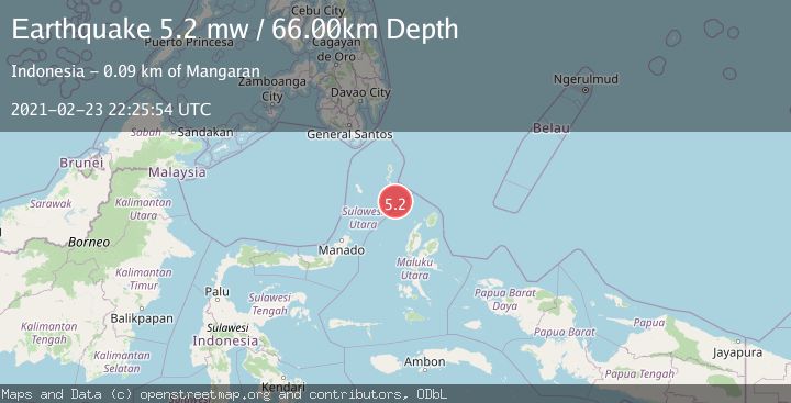
A 5.2 magnitude earthquake struck on KEPULAUAN TALAUD, INDONESIA, at Tue, 23 Feb 2021 22:25:54 GMT. Depth: 66km. Reviewed by EMSC seismologists, this moderate quake occurred at a magnitude type of mw.
Magnitude
5.2
mw
Source
EMSC
Intensity
-
Agency Reports
1 Sources| Source | Magnitude | Depth | Time |
|---|---|---|---|
| EMSCPrimary | 5.2 | 66 km | 4 years ago |
Earthquake Details
AutomaticEvent IDemsc_EMSC_20210223_0000172
Tsunami PotentialNo
Magnitude Typemw
Nearest Places
- Pulau Karis57.1 km
- Pulau Napumbalu66.3 km
- Tanjung Pallo77.1 km
- Tanjung Tatimbalangan77.8 km
- Damau78.3 km
Comments
Join the discussion about this event.
Latest Earthquakes
1.7Mag
Alaska Peninsula
Time1 minute ago
Depth0.00 km
SourceVYT (Automatic)
1.4Mag
Kenai Peninsula, Alaska
Time5 minutes ago
Depth1.95 km
SourceVYT (Automatic)
3.1Mag
Northern Sumatra, Indonesia
Time5 minutes ago
Depth14.69 km
SourceBMKG
1.9Mag
Channel Islands region, California
Time6 minutes ago
Depth2.81 km
SourceVYT (Automatic)
3.3Mag
Southern Alaska
Time12 minutes ago
Depth13.06 km
SourceVYT (Automatic)
Nearby Earthquakes
5.0Mag
KEPULAUAN TALAUD, INDONESIA
Time17 years ago
Depth80.00 km
SourceEMSC (Automatic)
3.1Mag
KEPULAUAN TALAUD, INDONESIA
Time0 months ago
Depth6.00 km
SourceBMKG (Automatic)
5.0Mag
KEPULAUAN TALAUD, INDONESIA
Time6 years ago
Depth70.00 km
SourceEMSC (Automatic)
5.5Mag
KEPULAUAN TALAUD, INDONESIA
Time3 years ago
Depth10.00 km
SourceEMSC (Automatic)
4.6Mag
KEPULAUAN TALAUD, INDONESIA
Time1 month ago
Depth51.00 km
SourceEMSC (Automatic)