Earthquake MOLUCCA SEA
Thu, 14 Oct 2021 15:16:31 GMT
Time4 years ago
Location
1.2000, 126.1400
Depth
60.0 KM
Event Summary
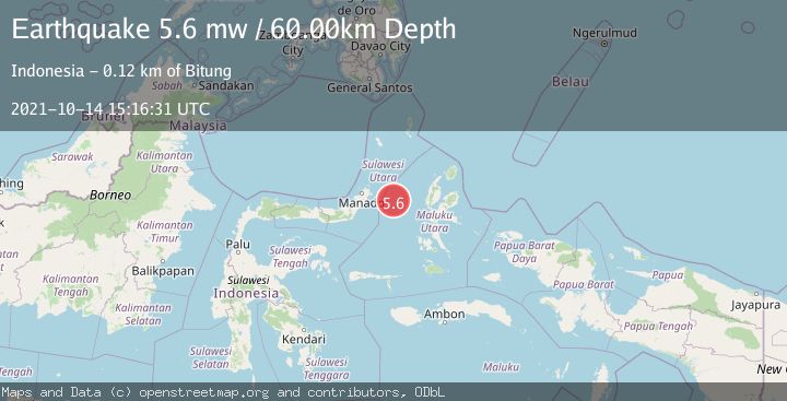
A 5.6 magnitude earthquake struck on MOLUCCA SEA, at Thu, 14 Oct 2021 15:16:31 GMT. Depth: 60km. Reviewed by EMSC seismologists, this moderate quake occurred at a magnitude type of mw.
Magnitude
5.6
mw
Source
EMSC
Intensity
-
Agency Reports
1 Sources| Source | Magnitude | Depth | Time |
|---|---|---|---|
| EMSCPrimary | 5.6 | 60 km | 4 years ago |
Earthquake Details
AutomaticEvent IDemsc_EMSC_20211014_0000180
Tsunami PotentialNo
Magnitude Typemw
Nearest Places
- Pulau Gureda23.7 km
- Kelurahan Pantai Sagu24.8 km
- Pulau Tifore25.2 km
- Kelurahan Tifure25.8 km
- Tanjung Geranomaderi28.1 km
Comments
Join the discussion about this event.
Latest Earthquakes
2.8Mag
OFFSHORE EL SALVADOR
Time3 minutes ago
Depth18.00 km
SourceINET (Automatic)
1.6Mag
Pyrenees
Time7 minutes ago
Depth0.00 km
SourceVYT (Automatic)
1.0Mag
110 km S of McCarthy, Alaska
Time8 minutes ago
Depth16.50 km
SourceUSGS (Automatic)
0.7Mag
Southern Alaska
Time15 minutes ago
Depth0.00 km
SourceVYT (Automatic)
2.4Mag
Minahassa Peninsula, Sulawesi
Time17 minutes ago
Depth9.93 km
SourceBMKG
Nearby Earthquakes
3.0Mag
MOLUCCA SEA
Time1 year ago
Depth25.00 km
SourceBMKG (Automatic)
5.4Mag
MOLUCCA SEA
Time1 year ago
Depth58.00 km
SourceEMSC (Automatic)
3.0Mag
MOLUCCA SEA
Time4 months ago
Depth26.00 km
SourceBMKG (Automatic)
3.1Mag
Northern Molucca Sea
Time3 weeks ago
Depth14.98 km
SourceBMKG (Automatic)
3.0Mag
MOLUCCA SEA
Time4 months ago
Depth24.00 km
SourceBMKG (Automatic)