Earthquake PHILIPPINE ISLANDS REGION
Sat, 03 Jan 2026 23:13:49 GMT
Time1 month ago
Location
5.9169, 127.1794
Depth
50.0 KM
Event Summary
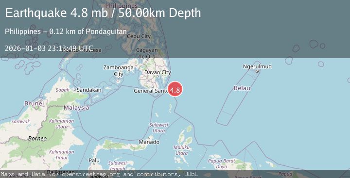
A 4.8 magnitude earthquake struck on PHILIPPINE ISLANDS REGION, at Sat, 03 Jan 2026 23:13:49 GMT. Depth: 50km. Reviewed by EMSC seismologists, this light quake occurred at a magnitude type of mb.
Magnitude
4.8
mb
Source
EMSC
Intensity
-
Agency Reports
1 Sources| Source | Magnitude | Depth | Time |
|---|---|---|---|
| EMSCPrimary | 4.8 | 50 km | 1 month ago |
Earthquake Details
AutomaticEvent IDemsc_EMSC_20260103_0000318
Tsunami PotentialNo
Magnitude Typemb
Nearest Places
- Tanjung Dapapa76.1 km
- Desa Pulau Miangas77.1 km
- Pulau Miangas77.1 km
- Kecamatan Miangas77.1 km
- Miangas77.8 km
Comments
Join the discussion about this event.
Latest Earthquakes
4.2Mag
Java, Indonesia
Time3 minutes ago
Depth95.46 km
SourceVYT (Automatic)
1.6Mag
Sumbawa region, Indonesia
Time3 minutes ago
Depth11.47 km
SourceVYT (Automatic)
3.0Mag
southern Sumatra, Indonesia
Time4 minutes ago
Depth37.96 km
SourceVYT (Automatic)
3.1Mag
Near North Coast of West Papua
Time6 minutes ago
Depth10.00 km
SourceBMKG
3.1Mag
Sweden
Time11 minutes ago
Depth0.00 km
SourceVYT (Automatic)
Nearby Earthquakes
5.3Mag
PHILIPPINE ISLANDS REGION
Time17 years ago
Depth60.00 km
SourceEMSC (Automatic)
4.0Mag
PHILIPPINE ISLANDS REGION
Time3 years ago
Depth15.00 km
SourcePIVS (Automatic)
3.2Mag
PHILIPPINE ISLANDS REGION
Time3 weeks ago
Depth4.00 km
SourcePIVS (Automatic)
3.0Mag
PHILIPPINE ISLANDS REGION
Time4 years ago
Depth108.00 km
SourcePIVS (Automatic)
3.0Mag
PHILIPPINE ISLANDS REGION
Time4 years ago
Depth40.00 km
SourcePIVS (Automatic)