Earthquake HALMAHERA, INDONESIA
Wed, 14 Jan 2026 18:00:27 GMT
Time1 month ago
Location
1.8842, 127.3539
Depth
109.0 KM
Event Summary
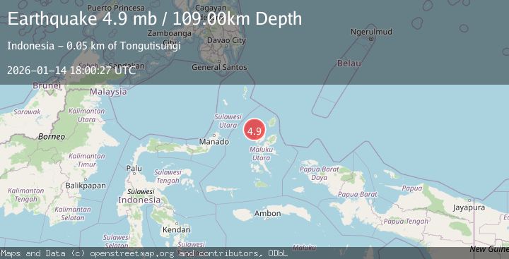
A 4.9 magnitude earthquake struck on HALMAHERA, INDONESIA, at Wed, 14 Jan 2026 18:00:27 GMT. Depth: 109km. Reviewed by EMSC seismologists, this light quake occurred at a magnitude type of mb.
Magnitude
4.9
mb
Source
EMSC
Intensity
-
Agency Reports
1 Sources| Source | Magnitude | Depth | Time |
|---|---|---|---|
| EMSCPrimary | 4.9 | 109 km | 1 month ago |
Earthquake Details
AutomaticEvent IDemsc_EMSC_20260114_0000256
Tsunami PotentialNo
Magnitude Typemb
Nearest Places
- Pulau Tutu25.8 km
- Tanjung Tutumadehe26.1 km
- Tanjung Tobadiku-mhe26.6 km
- Pulau Moreporoco27.0 km
- Pulau Tongidi27.3 km
Comments
Join the discussion about this event.
Latest Earthquakes
2.7Mag
Near North Coast of West Papua
Time13 minutes ago
Depth45.06 km
SourceBMKG
1.2Mag
Central Alaska
Time14 minutes ago
Depth0.85 km
SourceVYT (Automatic)
2.6Mag
West Papua Region, Indonesia
Time17 minutes ago
Depth10.00 km
SourceBMKG
2.3Mag
WESTERN TURKEY
Time20 minutes ago
Depth10.10 km
SourceKOERI (Automatic)
2.6Mag
Antofagasta, Chile
Time21 minutes ago
Depth0.00 km
SourceVYT (Automatic)
Nearby Earthquakes
5.5Mag
HALMAHERA, INDONESIA
Time21 years ago
Depth33.00 km
SourceEMSC (Automatic)
5.3Mag
HALMAHERA, INDONESIA
Time16 years ago
Depth110.00 km
SourceEMSC (Automatic)
4.0Mag
HALMAHERA, INDONESIA
Time6 years ago
Depth97.00 km
SourceDJA (Automatic)
5.0Mag
HALMAHERA, INDONESIA
Time9 years ago
Depth106.00 km
SourceEMSC (Automatic)
5.3Mag
HALMAHERA, INDONESIA
Time17 years ago
Depth100.00 km
SourceEMSC (Automatic)