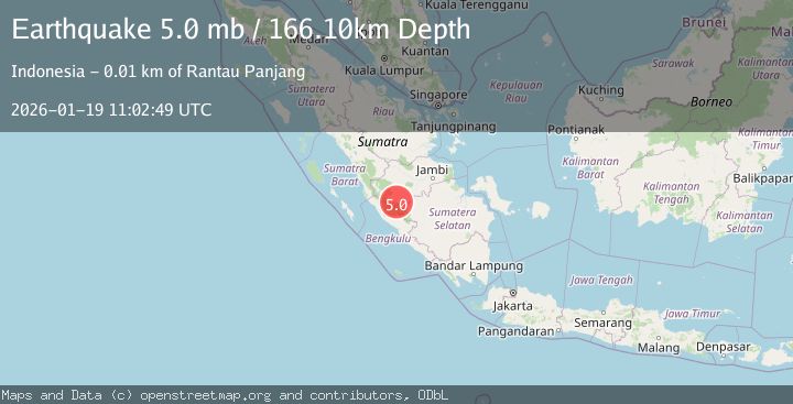
Earthquake SOUTHERN SUMATRA, INDONESIA
Mon, 19 Jan 2026 11:02:49 GMT
Time1 month ago
Location
-2.5902, 102.1773
Depth
166.1 KM
Event Summary
A 5.0 magnitude earthquake struck on SOUTHERN SUMATRA, INDONESIA, at Mon, 19 Jan 2026 11:02:49 GMT. Depth: 166.1km. Reviewed by EMSC seismologists, this moderate quake occurred at a magnitude type of mb.
Magnitude
5.0
mb
Source
EMSC
Intensity
-
Agency Reports
1 Sources| Source | Magnitude | Depth | Time |
|---|---|---|---|
| EMSCPrimary | 5.0 | 166 km | 1 month ago |
Earthquake Details
AutomaticEvent IDemsc_EMSC_20260119_0000127
Tsunami PotentialNo
Magnitude Typemb
Nearest Places
- Simpang0.0 km
- Renah Kemang0.9 km
- Narso Kecil1.6 km
- Sungai Keradak2.4 km
- Rantau Jankang2.8 km
Comments
Join the discussion about this event.
Latest Earthquakes
3.1Mag
Bali Region, Indonesia
Time1 day ago
Depth19.14 km
SourceBMKG
2.7Mag
Coquimbo, Chile
Time1 day ago
Depth14.16 km
SourceVYT (Automatic)
1.7Mag
Southeastern Alaska
Time1 day ago
Depth5.98 km
SourceVYT (Automatic)
2.1Mag
Tarapaca, Chile
Time1 day ago
Depth110.35 km
SourceVYT (Automatic)
2.7Mag
Minahassa Peninsula, Sulawesi
Time1 day ago
Depth114.15 km
SourceBMKG
Nearby Earthquakes
4.0Mag
SOUTHERN SUMATRA, INDONESIA
Time4 months ago
Depth140.00 km
SourceBMKG (Automatic)
3.0Mag
Southern Sumatra, Indonesia
Time1 week ago
Depth124.36 km
SourceBMKG (Automatic)
5.9Mag
SOUTHERN SUMATRA, INDONESIA
Time10 years ago
Depth153.00 km
SourceEMSC (Automatic)
3.0Mag
SOUTHERN SUMATRA, INDONESIA
Time2 years ago
Depth10.00 km
SourceBMKG (Automatic)
2.4Mag
southern Sumatra, Indonesia
Time1 week ago
Depth0.00 km
SourceVYT (Automatic)