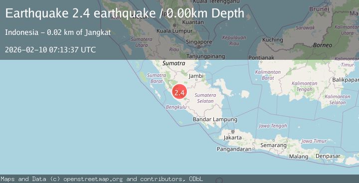
Earthquake southern Sumatra, Indonesia
Tue, 10 Feb 2026 07:13:37 GMT
Time1 hour ago
Location
-2.6767, 102.1308
Depth
0.0 KM
Event Summary
A 2.4 magnitude earthquake struck on southern Sumatra, Indonesia, at Tue, 10 Feb 2026 07:13:37 GMT. Depth: 0km. Reviewed by VYT seismologists, this minor quake occurred at a magnitude type of earthquake.
Magnitude
2.4
earthquake
Source
VYT
Intensity
-
Agency Reports
1 Sources| Source | Magnitude | Depth | Time |
|---|---|---|---|
| VYTPrimary | 2.4 | 0 km | 1 hour ago |
Earthquake Details
AutomaticEvent IDvyt_ce30cmsu5git
Tsunami PotentialNo
Magnitude Typeearthquake
Nearest Places
- Desa Batu Empang2.7 km
- Desa Simpang Narso3.1 km
- Bukit Gedang4.8 km
- Desa Bukit Berantai5.9 km
- Bukit Rantai9.4 km
Comments
Join the discussion about this event.
Latest Earthquakes
2.2Mag
Alaska Peninsula
Time1 hour ago
Depth27.95 km
SourceVYT (Automatic)
1.0Mag
Pyrenees
Time1 hour ago
Depth0.00 km
SourceVYT (Automatic)
1.9Mag
9 km NE of Pāhala, Hawaii
Time2 hours ago
Depth32.44 km
SourceUSGS (Automatic)
2.1Mag
55 km E of Pedro Bay, Alaska
Time2 hours ago
Depth111.20 km
SourceUSGS (Automatic)
0.8Mag
4 km WSW of The Geysers, CA
Time2 hours ago
Depth8.91 km
SourceUSGS (Automatic)
Nearby Earthquakes
3.0Mag
Southern Sumatra, Indonesia
Time2 days ago
Depth124.36 km
SourceBMKG (Automatic)
2.7Mag
Southern Sumatra, Indonesia
Time2 weeks ago
Depth129.75 km
SourceBMKG (Automatic)
2.9Mag
Southern Sumatra, Indonesia
Time2 weeks ago
Depth14.34 km
SourceBMKG (Automatic)
2.8Mag
Southern Sumatra, Indonesia
Time1 week ago
Depth39.99 km
SourceBMKG (Automatic)
2.9Mag
SOUTHERN SUMATRA, INDONESIA
Time3 days ago
Depth58.00 km
SourceBMKG (Automatic)