Earthquake EAST OF KURIL ISLANDS
Thu, 05 Feb 2026 10:16:25 GMT
Time2 weeks ago
Location
49.5100, 158.1200
Depth
10.0 KM
Event Summary
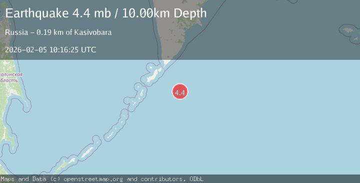
A 4.4 magnitude earthquake struck on EAST OF KURIL ISLANDS, at Thu, 05 Feb 2026 10:16:25 GMT. Depth: 10km. Reviewed by GSRAS seismologists, this light quake occurred at a magnitude type of mb.
Magnitude
4.4
mb
Source
GSRAS
Intensity
-
Agency Reports
1 Sources| Source | Magnitude | Depth | Time |
|---|---|---|---|
| GSRASPrimary | 4.4 | 10 km | 2 weeks ago |
Earthquake Details
AutomaticEvent IDemsc_GSRAS_20260205_0000183
Tsunami PotentialNo
Magnitude Typemb
Nearest Places
- Oyashio97.2 km
- Skala Vladimira164.0 km
- Rif Nezametnyy165.3 km
- Mel’ Koksher165.4 km
- Banka Kazach’ya170.4 km
Comments
Join the discussion about this event.
Latest Earthquakes
3.7Mag
Kepulauan Tanimbar, Indonesia
Time10 minutes ago
Depth10.00 km
SourceVYT (Automatic)
4.6Mag
West Papua Region, Indonesia
Time10 minutes ago
Depth24.86 km
SourceBMKG
1.5Mag
35 km SE of Minto, Alaska
Time14 minutes ago
Depth0.10 km
SourceUSGS (Automatic)
3.7Mag
Banda Sea
Time14 minutes ago
Depth237.55 km
SourceVYT (Automatic)
2.2Mag
AEGEAN SEA
Time15 minutes ago
Depth12.80 km
SourceKOERI (Automatic)
Nearby Earthquakes
5.2Mag
EAST OF KURIL ISLANDS
Time20 years ago
Depth30.00 km
SourceEMSC (Automatic)
4.4Mag
EAST OF KURIL ISLANDS
Time2 days ago
Depth50.00 km
SourceGSRAS (Automatic)
5.6Mag
EAST OF KURIL ISLANDS
Time3 months ago
Depth10.90 km
SourceEMSC (Automatic)
4.0Mag
EAST OF KURIL ISLANDS
Time9 months ago
Depth10.00 km
SourceGSRAS (Automatic)
6.2Mag
EAST OF KURIL ISLANDS
Time6 months ago
Depth9.00 km
SourceEMSC (Automatic)