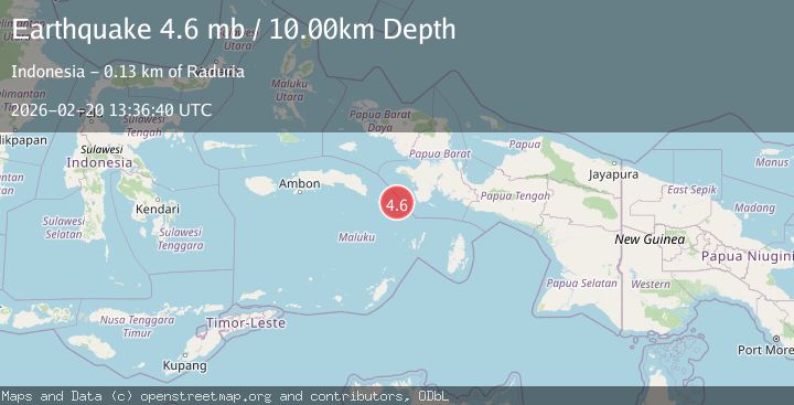
Earthquake West Papua Region, Indonesia
Fri, 20 Feb 2026 13:36:45 GMT
Time1 hour ago
Location
-3.9012, 132.0073
Depth
51.8 KM
Event Summary
A 4.2 magnitude earthquake struck on West Papua Region, Indonesia, at Fri, 20 Feb 2026 13:36:45 GMT. Depth: 51.789486km. Reviewed by BMKG seismologists, this light quake occurred at a magnitude type of M.
Magnitude
4.2
M
Source
BMKG
Intensity
-
Agency Reports
1 Sources| Source | Magnitude | Depth | Time |
|---|---|---|---|
| BMKGPrimary | 4.2 | 52 km | 1 hour ago |
Earthquake Details
ManualEvent IDbmg2026dokc
Tsunami PotentialNo
Magnitude TypeM
Nearest Places
- Pulau Oirang64.1 km
- Kilkoda64.1 km
- Bas64.2 km
- Desa Kota Sirih64.5 km
- Tanjung Owan64.5 km
Comments
Join the discussion about this event.
Latest Earthquakes
1.5Mag
35 km SE of Minto, Alaska
Time1 hour ago
Depth0.10 km
SourceUSGS (Automatic)
3.7Mag
Banda Sea
Time1 hour ago
Depth237.55 km
SourceVYT (Automatic)
0.7Mag
Washington
Time1 hour ago
Depth3.42 km
SourceVYT (Automatic)
2.7Mag
Western Australia
Time1 hour ago
Depth485.47 km
SourceVYT (Automatic)
3.8Mag
Sumba region, Indonesia
Time1 hour ago
Depth127.93 km
SourceVYT (Automatic)
Nearby Earthquakes
3.1Mag
West Papua Region, Indonesia
Time1 week ago
Depth10.20 km
SourceBMKG
3.9Mag
Ceram Sea, Indonesia
Time1 hour ago
Depth160.52 km
SourceVYT (Automatic)
4.4Mag
Papua region, Indonesia
Time1 week ago
Depth585.69 km
SourceVYT (Automatic)
5.0Mag
CERAM SEA, INDONESIA
Time17 years ago
Depth40.00 km
SourceGFZ (Automatic)
2.7Mag
BANDA SEA
Time2 weeks ago
Depth92.00 km
SourceBMKG (Automatic)