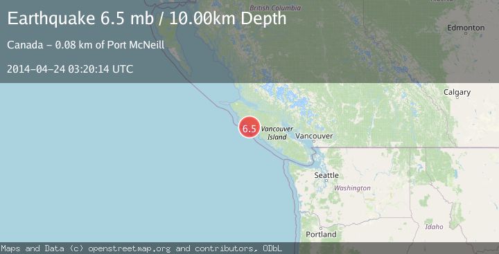
Earthquake VANCOUVER ISLAND, CANADA REGION
Thu, 24 Apr 2014 03:20:14 GMT
Time11 years ago
Location
49.8500, -127.1900
Depth
10.0 KM
Event Summary
A 6.5 magnitude earthquake struck on VANCOUVER ISLAND, CANADA REGION, at Thu, 24 Apr 2014 03:20:14 GMT. Depth: 10km. Reviewed by NEIC seismologists, this strong quake occurred at a magnitude type of mb.
Magnitude
6.5
mb
Source
NEIC
Intensity
-
Agency Reports
2 Sources| Source | Magnitude | Depth | Time |
|---|---|---|---|
| NEICPrimary | 5.0 | 10 km | 11 years ago |
| EMSC | 6.5 | 10 km | 11 years ago |
Earthquake Details
AutomaticEvent IDemsc_NEIC_20140424_0000013
Tsunami PotentialNo
Magnitude Typemb
Nearest Places
- 2.8 km
- 2.9 km
- 3.4 km
- 3.4 km
- 3.8 km
Comments
Join the discussion about this event.
Latest Earthquakes
0.8Mag
Southern Alaska
Time15 hours ago
Depth0.00 km
SourceVYT (Automatic)
1.8Mag
Central Alaska
Time15 hours ago
Depth15.99 km
SourceVYT (Automatic)
2.6Mag
West Papua Region, Indonesia
Time15 hours ago
Depth10.00 km
SourceBMKG
3.1Mag
near the north coast of Papua, Indonesia
Time15 hours ago
Depth10.00 km
SourceVYT (Automatic)
2.7Mag
Flores region, Indonesia
Time15 hours ago
Depth143.43 km
SourceVYT (Automatic)
Nearby Earthquakes
5.5Mag
VANCOUVER ISLAND, CANADA REGION
Time12 years ago
Depth10.00 km
SourceEMSC (Automatic)
3.0Mag
Vancouver Island, Canada region
Time1 week ago
Depth25.88 km
SourceVYT (Automatic)
3.0Mag
VANCOUVER ISLAND, CANADA REGION
Time7 months ago
Depth21.30 km
SourceCN (Automatic)
6.4Mag
VANCOUVER ISLAND, CANADA REGION
Time14 years ago
Depth20.00 km
SourceEMSC (Automatic)
3.0Mag
VANCOUVER ISLAND, CANADA REGION
Time5 years ago
Depth10.00 km
SourceCN (Automatic)