Earthquake KEPULAUAN BARAT DAYA, INDONESIA
Mon, 05 Aug 2019 01:52:15 GMT
Time6 years ago
Location
-7.5400, 127.4900
Depth
159.0 KM
Event Summary
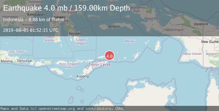
A 4.0 magnitude earthquake struck on KEPULAUAN BARAT DAYA, INDONESIA, at Mon, 05 Aug 2019 01:52:15 GMT. Depth: 159km. Reviewed by NEIC seismologists, this light quake occurred at a magnitude type of mb.
Magnitude
4.0
mb
Source
NEIC
Intensity
-
Agency Reports
1 Sources| Source | Magnitude | Depth | Time |
|---|---|---|---|
| NEICPrimary | 4.0 | 159 km | 6 years ago |
Earthquake Details
AutomaticEvent IDemsc_NEIC_20190805_0000163
Tsunami PotentialNo
Magnitude Typemb
Nearest Places
- Pulau Telang5.6 km
- Pulau Limutu6.4 km
- Pulau Laut7.2 km
- Pulau Kital7.4 km
- Jerusu7.5 km
Comments
Join the discussion about this event.
Latest Earthquakes
1.4Mag
Southern Alaska
Time2 minutes ago
Depth44.07 km
SourceVYT (Automatic)
0.7Mag
8 km NW of The Geysers, CA
Time9 minutes ago
Depth1.59 km
SourceUSGS (Automatic)
1.2Mag
Southern Alaska
Time10 minutes ago
Depth16.72 km
SourceVYT (Automatic)
1.6Mag
49 km W of Mentone, Texas
Time10 minutes ago
Depth4.59 km
SourceUSGS (Automatic)
3.1Mag
northern Colombia
Time12 minutes ago
Depth219.97 km
SourceVYT (Automatic)
Nearby Earthquakes
5.5Mag
KEPULAUAN BARAT DAYA, INDONESIA
Time18 years ago
Depth150.00 km
SourceEMSC (Automatic)
5.8Mag
KEPULAUAN BARAT DAYA, INDONESIA
Time18 years ago
Depth179.00 km
SourceEMSC (Automatic)
5.1Mag
KEPULAUAN BARAT DAYA, INDONESIA
Time19 years ago
Depth136.00 km
SourceEMSC (Automatic)
4.0Mag
KEPULAUAN BARAT DAYA, INDONESIA
Time3 years ago
Depth146.00 km
SourceNEIC (Automatic)
7.3Mag
KEPULAUAN BARAT DAYA, INDONESIA
Time4 years ago
Depth170.00 km
SourceEMSC (Automatic)