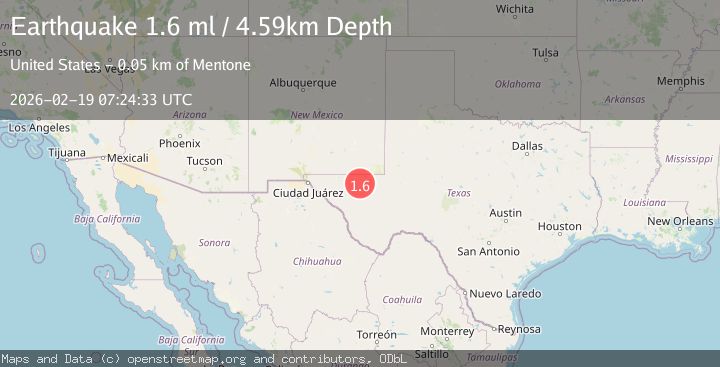
Earthquake 49 km W of Mentone, Texas
Thu, 19 Feb 2026 07:24:33 GMT
Time1 hour ago
Location
31.6730, -104.1180
Depth
4.6 KM
Event Summary
A 1.6 magnitude earthquake struck on 49 km W of Mentone, Texas, at Thu, 19 Feb 2026 07:24:33 GMT. Depth: 4.5908km. Reviewed by USGS seismologists, this minor quake occurred at a magnitude type of ml.
Magnitude
1.6
ml
Source
USGS
Intensity
-
Agency Reports
1 Sources| Source | Magnitude | Depth | Time |
|---|---|---|---|
| USGSPrimary | 1.6 | 5 km | 1 hour ago |
Earthquake Details
AutomaticEvent IDusgs_tx2026dmnifc
Tsunami PotentialNo
Magnitude Typeml
Nearest Places
- Old Michigan Mine3.9 km
- Monument Draw4.2 km
- Kyle Quarry4.6 km
- Salt Spring4.6 km
- Virginia Draw4.9 km
Comments
Join the discussion about this event.
Latest Earthquakes
2.1Mag
Tarapaca, Chile
Time33 minutes ago
Depth115.11 km
SourceVYT (Automatic)
1.7Mag
35 km SSE of King Salmon, Alaska
Time34 minutes ago
Depth9.10 km
SourceUSGS (Automatic)
2.1Mag
Sweden
Time38 minutes ago
Depth0.00 km
SourceVYT (Automatic)
2.2Mag
Minahassa Peninsula, Sulawesi
Time39 minutes ago
Depth24.60 km
SourceBMKG
2.0Mag
Tarapaca, Chile
Time39 minutes ago
Depth26.98 km
SourceVYT (Automatic)
Nearby Earthquakes
1.7Mag
49 km W of Mentone, Texas
Time2 days ago
Depth4.51 km
SourceUSGS (Automatic)
1.7Mag
48 km W of Mentone, Texas
Time1 day ago
Depth5.91 km
SourceUSGS (Automatic)
3.8Mag
western Texas
Time2 days ago
Depth0.00 km
SourceVYT (Automatic)
1.7Mag
50 km W of Mentone, Texas
Time1 day ago
Depth5.67 km
SourceUSGS (Automatic)
1.8Mag
western Texas
Time1 day ago
Depth5.74 km
SourceVYT (Automatic)